
I had an adventure of a lifetime.
Noel Oliver
Following the Path of Lewis and Clark
In summary, the journey was 8,981 miles long from start to finish. I was gone from home for a total of 52 days. I purchased 458.5 gallons of fuel (average of more than 19 mpg). I took over 2,500 photographs. I visited 15 states. I witnessed no vehicle crashes, only saw one semi on it’s side in the median. I was never stopped by any police agencies. I didn’t lose anything along the way. The only problem with my truck was a crack in the windshield that has remained stable.
Journey Overview
About 58 years ago, I had a fifth grade teacher that taught me a brief overview of Lewis and Clark and their adventure to the Northwest. My fascination and curiosity about that historic journey continues to this day.
 I have always wanted to know more about the “Corps of Discovery” and the places they traveled. I have always wanted to sit on the banks of the Missouri River and try to mentally venture back to their time, the early 1800’s. I have always felt that if I had been available at that time, I would have volunteered to be part of their crew.
Well, now that I am retired, I am determined to travel that path as well as can be done in this modern era. I will not be able to travel by boat up the river or hike over the mountains or even fight the grizzly bears, but I will be able to visit many of the same places they traveled and examine all the monuments and museums along the way.
Leaving April 1, 2013 and take about a month to travel along their path from the Mississippi River to the point that the Columbia River empties into the Pacific Ocean. I will be traveling by pick-up truck with a very flexible itinerary and a determination to share my experiences with all that might be interested, especially elementary school students. This round-trip is expected to be about 6,000 miles and include at least 11 states.
As I travel, I will be compiling a daily blog that can easily be accessed on the internet. I will be including photos, videos, and written dialogue that hopefully will intrigue the interested viewers. Of course, I will be giving the story from a layman point of view and probably not up to the standards of our well-trained teachers, but I hope the teachers can include some of my work in their lessons to the students.
Journey Timeline
Journey Journal
Browse through all of the journal entries from the trip.
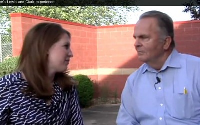
KHQA Noel Oliver’s Lewis and Clark Experience
He followed in the footsteps of Lewis and Clark. Tuesday, Noel Oliver stopped by KHQA to share his experiences with KHQA’s Brooke...
Selected Photos
I have selected some of the better photos that give an overall view of the entire journey. [alpine-phototile-for-picasa-and-google-plus src=”user_album” uid=”117292386093793315084″ ualb=”5885388523482493249″ imgl=”fancybox” dltext=”Picasa” style=”floor” row=”4″ num=”190″ size=”220″ border=”1″ highlight=”1″ align=”center”...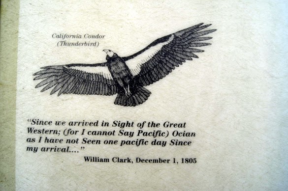
After 28 days, it is over.
The Pacific was the destination assigned by President Jefferson and The Corps succeeded. So many months, and days, and miles, and troubles, and struggles and yet it is sad that it is over. That pretty well describes the feelings of Captains Lewis and Clark; and I must say it also describes my feelings. This afternoon, I am sad that it is over. I can honestly say that I have “planned” or at least dreamt about this journey since I was a young boy. Of course I didn’t know everything about their journey and I still don’t, even after this trip, but I knew enough about it that it created a deep curiosity and a yearning in me. I wanted to see at least some of the places they described and to contemplate their strengths and their drive. Now I have done just that. Numerous times, over the last 28 days, I have stood at the river bank, read a selection from their journals, looked upstream and pictured them rounding the bend headed west. I didn’t get to see any live grizzly bears and I didn’t get to the point that I had to eat anything undesirable, but I did see buffalos, an elk, a few bald eagles, a lot of ring-necked pheasants, and even a few prairie dogs. I didn’t have to “camp” in my truck even though I was prepared to do it if necessary. I did struggle a few days in the snow and several days in the rain, but I also had some beautiful sunshine that kept my spirits up. I ventured off the Lewis and Clark journey...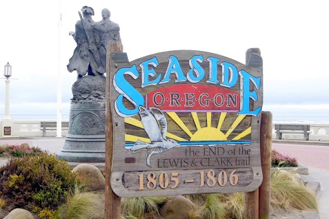
04-27-2013
Cold, windy, and rainy; just as described in all their journals. The Oregon coast lived up to their descriptions in all aspects. A beautiful coast for sure, but cold and damp all day. As the one sign says, “The end of the Lewis and Clark Trail”. Seaside, OR N46.01491 W123.91120 Salt Works N45.98466 W123.93213 Ecola State Park N45.91955 W123.97405 Daily data: Beginning odometer at Comfort Inn, Astoria, OR was 31,025 miles. Ending odometer at the same place is 31,071 miles. Bought fuel at Astoria, OR. Bought 9.333 gallons @ $3.439 for a total of $32.10. [alpine-phototile-for-picasa-and-google-plus src=”user_album” uid=”117292386093793315084″ ualb=”5871666593272316209″ imgl=”fancybox” dltext=”Picasa” style=”floor” row=”4″ num=”150″ size=”220″ border=”1″ highlight=”1″ align=”center”...
04-26-2013
“Ocian in view ! O! the joy” Everyone was thrilled to learn that they actually made it to the Pacific Ocean as directed by President Jefferson. BUT, the last several days were not easy, in fact they were miserable but they made it. Daily data: Beginning odometer at the Days Inn in Greshem, Oregon was 30,806 miles. Ending odometer at the Comfort Inn in Astoria, Oregon is 30,997 miles. Fuel purchase at Cathlamet, Washington. Odometer was 30890, bought 12.443 gallons @ $3.739 for a total of $46.52.Meals for the day were $28.00 Meals for the day were $28.00 Lodging for the night is $105.60 [alpine-phototile-for-picasa-and-google-plus src=”user_album” uid=”117292386093793315084″ ualb=”5871345920197158977″ imgl=”fancybox” dltext=”Picasa” style=”floor” row=”4″ num=”150″ size=”220″ border=”1″ highlight=”1″ align=”center”...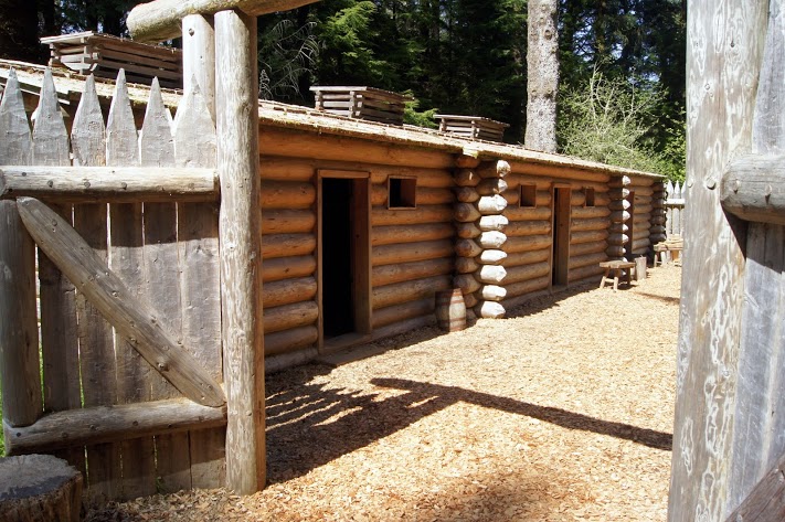
Fort Clatsop
A fort, hastily built to survive the cold, wet winter of the Columbia River and the Pacific Ocean. Arriving in mid-November, the fort had to be built quickly to assist in their survival for the winter. The fort is much smaller than I expected, but it obviously fit their needs. N46.13397 W123.88036 [alpine-phototile-for-picasa-and-google-plus src=”user_album” uid=”117292386093793315084″ ualb=”5871344913245914625″ imgl=”fancybox” dltext=”Picasa” style=”floor” row=”4″ num=”150″ size=”220″ border=”1″ highlight=”1″ align=”center”...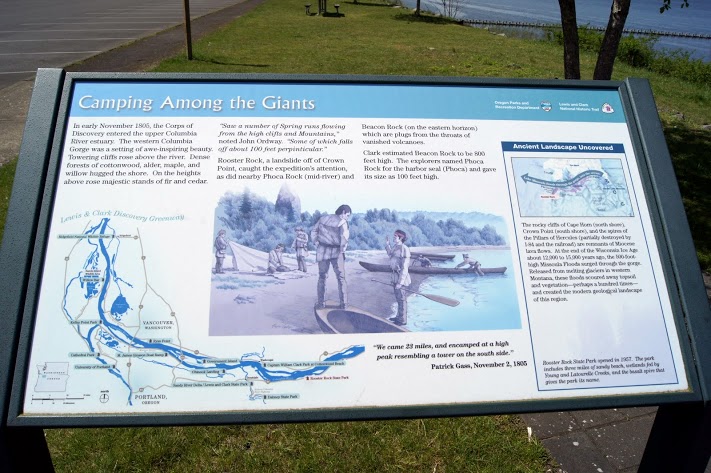
04-25-2013
I didn’t cover many miles, but I did stay right on the river all day and saw some amazing sights. A few mountain streams and a departing view of Mt. Hood, which I think is one of my favorite places so far. Daily data: Beginning odometer at Best Western on Mt. Hood was 30,700 miles. Ending odometer at Days Inn in Gresham, Oregon is 30,805 miles. Bought fuel at Mt. Hood. Bought 9.687 galloons @ $4.129 for a total of 40.00. This was not a fill-up because of the price per gallon. I just wanted enough to be sure I could get down the mountain. Meals for the day was $29.00. Lodging for tonight is $65.57 + April 25, 2013 [alpine-phototile-for-picasa-and-google-plus src=”user_album” uid=”117292386093793315084″ ualb=”5870937786967077329″ imgl=”fancybox” dltext=”Picasa” style=”floor” row=”4″ num=”150″ size=”220″ border=”1″ highlight=”1″ align=”center”...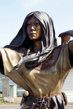
Columbia River Locks and Dams
Water level control, power production, transportation support and fish management; at the highest level. Very impressive operations. Although Lewis and Clark didn’t have to deal with them, the river is more navigable and the salmon are thriving. Cascade Locks N45.67088 W121.89283 Bonneville Dam N45.64223 W121.94269 [alpine-phototile-for-picasa-and-google-plus src=”user_album” uid=”117292386093793315084″ ualb=”5870939277808707121″ imgl=”fancybox” dltext=”Picasa” style=”floor” row=”4″ num=”150″ size=”220″ border=”1″ highlight=”1″ align=”center”...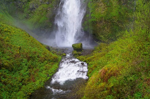
Columbia River Gorge Waterfalls
Surprisingly beautiful waterfalls Reminds me of some I saw in Hawaii. The walls of the gorge are steep and rocky with very thick greenery so it should not be a surprise that springs and snow melt would produce some pretty grand waterfalls. Horsetail Falls N45.59049 W122.06858 Multomah Falls N45.57842 W122.11894 [alpine-phototile-for-picasa-and-google-plus src=”user_album” uid=”117292386093793315084″ ualb=”5870941514422922305″ imgl=”fancybox” dltext=”Picasa” style=”floor” row=”4″ num=”150″ size=”220″ border=”1″ highlight=”1″ align=”center”...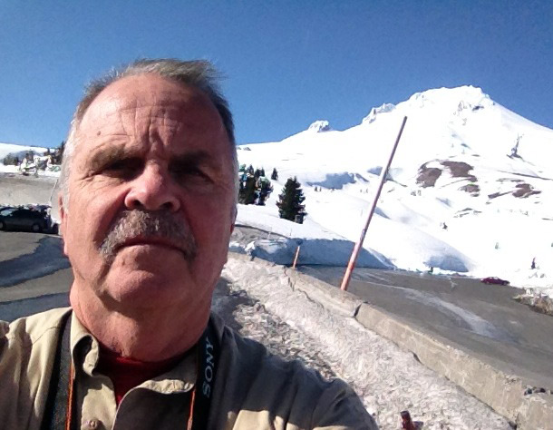
Mt. Hood Oregon
Mt. Hood had little to do with the Corps of Discovery journey, but they did see it and include it in their diaries as a major landmark. Its snow covered, pointed top is visible for more than 50 miles on the Columbia River. As you approach, mile by mile, it keeps getting bigger and taller. Now that I am here on the top, it is as majestic as I expected. N45.30312 W121.76526 Elevation 5,911 feet Daily data: Beginning odometer at Days Inn in Kennewick, WA was 30,488 miles Ending odometer at Best Western, Government Camp, Mt. Hood, Oregon is 30699 miles Meals were $24.00. Fuel purchased at Kennewick, WA, odometer 30448, bought 11.452 gallons @ $3.539 for a total of $40.53. Lodging for tonight is $88.16. [alpine-phototile-for-picasa-and-google-plus src=”user_album” uid=”117292386093793315084″ ualb=”5870593768737720321″ imgl=”fancybox” dltext=”Picasa” style=”floor” row=”4″ num=”150″ size=”220″ border=”1″ highlight=”1″ align=”center”...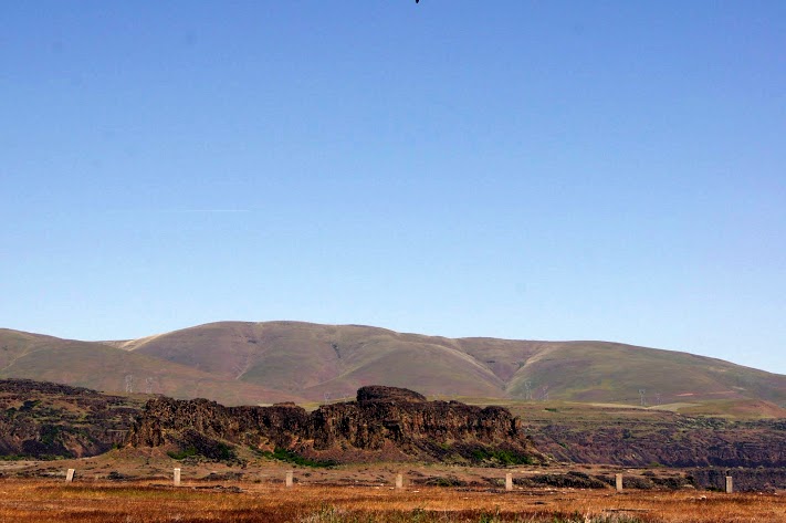
Columbia River Gorge
The Columbia River and the gorge it has created is the border between Oregon and Washington for the most part. Lewis and Clark were traveling pretty quickly on this part of their journey, but did run into difficulties with some of the rapids. Even though it was down stream, it was never easy or routine for them. [alpine-phototile-for-picasa-and-google-plus src=”user_album” uid=”117292386093793315084″ ualb=”5870586834439071281″ imgl=”fancybox” dltext=”Picasa” style=”floor” row=”4″ num=”150″ size=”220″ border=”1″ highlight=”1″ align=”center”...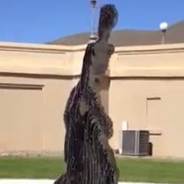
Maryhill Museum – Disappearing Statue
Here is a video of the disappearing statue.
04-23-2013
Today’s travels show the variety of scenery on the Washington/Oregon State lines. A variety of terrains, vegetation and uses in just a relatively short distance. Some of the farm field photos make me think that their equipment must have seat belts and roll cages. They farm some pretty steep slopes and it makes some beautiful scenes. Daily data: Beginning odometer at Motel 6 in Clarkston, Washington was 30,210. Ending odometer at Days Inn in Kennewick, Washington is 30,448. One fuel stop at Clarkston. Odometer was 30,211. Bought 7,805 gallons @ $3.459 for a total of $27.00. Meals were $21.00 Lodging for tonight is $78.71. + April 23, 2013 [alpine-phototile-for-picasa-and-google-plus src=”user_album” uid=”117292386093793315084″ ualb=”5870213532276223009″ imgl=”fancybox” dltext=”Picasa” style=”floor” row=”4″ num=”150″ size=”220″ border=”1″ highlight=”1″ align=”center”...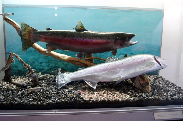
McNary Beach and Dam
Of course this dam was not here when Lewis and Clark came through here, but it does give you an idea of how big the Columbia River really is. N45.93126 W119.29973 Elevation 269 feet [alpine-phototile-for-picasa-and-google-plus src=”user_album” uid=”117292386093793315084″ ualb=”5870211699186549761″ imgl=”fancybox” dltext=”Picasa” style=”floor” row=”4″ num=”150″ size=”220″ border=”1″ highlight=”1″ align=”center”...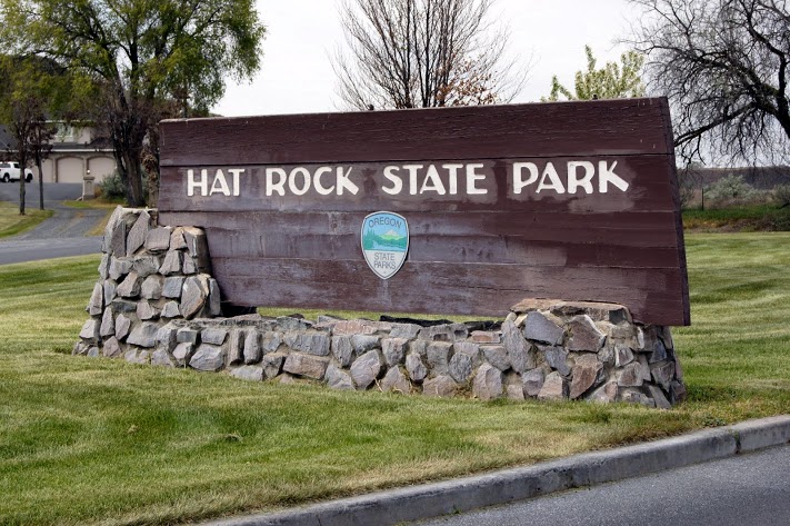
Hat Rock
Why would the Corps of Discovery call this Hat Rock? More than one of their journals made note of this landmark. It was obvious to them from the river and they saw it on both their westbound journey and when they returned on their eastbound trip. N45.91765 W119.17062 Elevation 387 feet [alpine-phototile-for-picasa-and-google-plus src=”user_album” uid=”117292386093793315084″ ualb=”5870210419449301297″ imgl=”fancybox” dltext=”Picasa” style=”floor” row=”4″ num=”150″ size=”220″ border=”1″ highlight=”1″ align=”center”...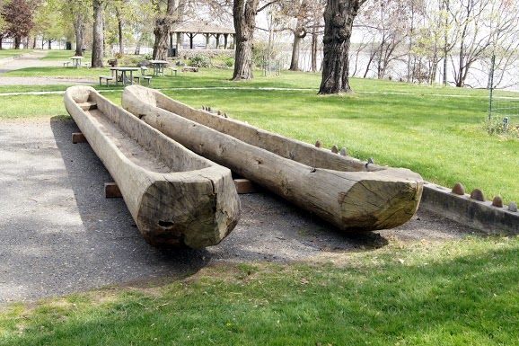
Snake River and Columbia River Confluence
Finally, they saw the Columbia River. The whole Corps was excited to finally get on the Columbia River because it was “all down hill from here”. Traveling downstream was so much faster than what they had been doing, it seemed almost effortless. The State of Washington chose this significant location to honor Sacagawea by establishing Sacagawea State Park and establishing a modest museum in her honor. N46.20032 W119.03932 Elevation 371 feet [alpine-phototile-for-picasa-and-google-plus src=”user_album” uid=”117292386093793315084″ ualb=”5870207325787929281″ imgl=”fancybox” dltext=”Picasa” style=”floor” row=”4″ num=”150″ size=”220″ border=”1″ highlight=”1″ align=”center”...
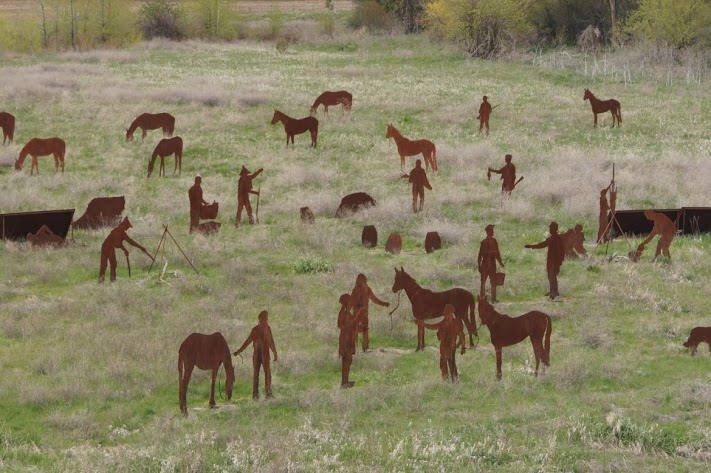
Patit Creek Campsite
View both the campsite and all the players here. This campsite includes a pretty complete set of iron cutouts representing the people and activities of the campsite. Very interesting and well done. N46.34586 W117.93604 Elevation 1761 feet [alpine-phototile-for-picasa-and-google-plus src=”user_album” uid=”117292386093793315084″ ualb=”5870206100352623985″ imgl=”fancybox” dltext=”Picasa” style=”floor” row=”4″ num=”150″ size=”220″ border=”1″ highlight=”1″ align=”center”...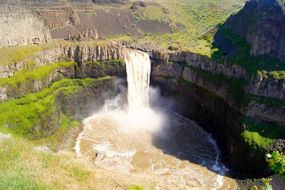
Palouse Falls, Washington
One of the most beautiful water falls in all of Washington. These falls are the only remaining major falls created by glacial floods 15,000 years ago. The Ranger related that the water is not always that muddy. The color is due to a heavy rain just the day before. N46.66368 W118.22744 Elevation 899 feet Daily data: Beginning odometer at Comfort Inn, Lewiston, Idaho was 30025. Ending odometer at Motel 6, Clarkston, Washington is 30,210. Fuel purchased at Clarkston, WA, odometer 30060, 12.860 gallons @ $3.459 for a total of $44.48. Meals for the day were $22.00 Lodging for the day is $47.07 [alpine-phototile-for-picasa-and-google-plus src=”user_album” uid=”117292386093793315084″ ualb=”5869850504698023649″ imgl=”fancybox” dltext=”Picasa” style=”floor” row=”4″ num=”150″ size=”220″ border=”1″ highlight=”1″ align=”center”...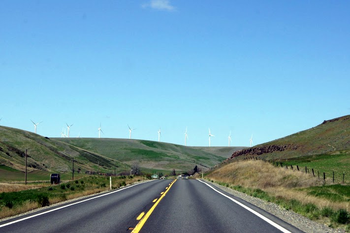
More Highway 12 travel photos
After spending most of yesterday on Highway 12 in Idaho, today is the same highway in Washington, still scenic. [alpine-phototile-for-picasa-and-google-plus src=”user_album” uid=”117292386093793315084″ ualb=”5869848744875473825″ imgl=”fancybox” dltext=”Picasa” style=”floor” row=”4″ num=”150″ size=”220″ border=”1″ highlight=”1″ align=”center”...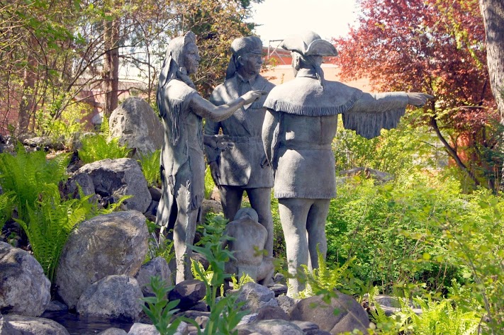
Lewis and Clark State College, Lewiston, Idaho
The statutes in their outdoor mall are outstanding. Probably the best Sacajawea that I have seen. N46.41265 W117.02633 Elevation 859 feet [alpine-phototile-for-picasa-and-google-plus src=”user_album” uid=”117292386093793315084″ ualb=”5869845622437523745″ imgl=”fancybox” dltext=”Picasa” style=”floor” row=”4″ num=”150″ size=”220″ border=”1″ highlight=”1″ align=”center”...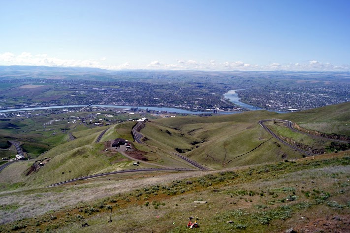
Three states overlook
From this vantage point, you can see Idaho, Washington and Oregon. N46.46041 W117.01647 Elevation 2598 feet [alpine-phototile-for-picasa-and-google-plus src=”user_album” uid=”117292386093793315084″ ualb=”5869844869455354017″ imgl=”fancybox” dltext=”Picasa” style=”floor” row=”4″ num=”150″ size=”220″ border=”1″ highlight=”1″ align=”center”...
Lewiston and Clarkson, Idaho and Washington
Separated only by the Snake River, tourists and residents alike travel back and forth quite often. [alpine-phototile-for-picasa-and-google-plus src=”user_album” uid=”117292386093793315084″ ualb=”5869843879291425841″ imgl=”fancybox” dltext=”Picasa” style=”floor” row=”4″ num=”150″ size=”220″ border=”1″ highlight=”1″ align=”center”...
04-21-2013
Highway 12 in Idaho is possibly the most scenic drive I have ever taken. The range of altitudes, weather, scenery, and history, all make this an unforgettable day of driving. It was much more than I expected today, it was remarkable. There were times when I was nervous about the visibility and driving conditions, but even then I was stunned by the beauty. Lewis and Clark faced these same conditions and the comments in their journals reflected the same awe that I felt today. At the Lolo Summit, I wanted to walk some of the same trails that the Corps traveled, the peaks of the Bitterroot Mountains. The Ranger there said I was welcome to do that, but she warned me that the snow varied from 5 feet to 7 feet on those trails. She also advised that the snow will probably remain on those trails well into June. Needless to say, I didn’t take that hike. Highway 12 follows the rivers from the summit to the valley below and there is new beauty at every turn. I can only imagine this drive in a convertible in warm weather or maybe a Harley. The altitude at Lolo summit was 5,366 feet. Daily data: Beginning odometer at Super 8 in Missoula, Montana was 29,794 miles. Ending odometer at Comfort Inn at Lewiston, Idaho is 30,019 miles. Fuel stop at Missoula. 10.368 gallons @ $3.259 for a total of $33.79. Meals for the day were $24.00 Lodging for tonight is $79.74. [alpine-phototile-for-picasa-and-google-plus src=”user_album” uid=”117292386093793315084″ ualb=”5869457400327670465″ imgl=”fancybox” dltext=”Picasa” style=”floor” row=”4″ num=”150″ size=”220″ border=”1″ highlight=”1″ align=”center”...
04-20-2013
The Chief said “I have never met men without blankets…” Extremes in altitude and temperature today, in a 200 mile drive. The highest point for the day was Big Hole Pass at 7,400 feet. Other significant altitudes were: Badger Pass at 6,694 feet, and Grasshopper Creek at 6,714 feet. Chief Joseph Pass at 7,265 feet is the one with all the snow, even the path to the outhouse is drifted. No, that’s not me fishing. I only wish that it was. Daily data: Beginning odometer at Best Western in Dillon, Montana was 29,586. Ending mileage at Super 8 at Missoula, Montana was 29,789 miles. Meals for the day cost $22.00. Lodging for the night is $60.55. [alpine-phototile-for-picasa-and-google-plus src=”user_album” uid=”117292386093793315084″ ualb=”5869077870147628225″ imgl=”fancybox” dltext=”Picasa” style=”floor” row=”4″ num=”150″ size=”220″ border=”1″ highlight=”1″ align=”center”...
04-19-2013
Day 19 of my journey tours a good portion of Western Montana. Includes a few odds and ends visited along the day’s travels. The photos will also show that to follow as near as possible along the Missouri River, there are some pretty narrow, winding dirt roads. Daily data: Beginning odometer at Super 8 in Helena, Montana was 29,405 miles. Ending odometer at Best Western in Dillon, Montana is 29,582 miles Meals for the day were $22.00 Fuel bought at Helena, 10.654 gallons @ $3.269 for a total of $34.83 + April 19, 2013 [alpine-phototile-for-picasa-and-google-plus src=”user_album” uid=”117292386093793315084″ ualb=”5868714806476065073″ imgl=”fancybox” dltext=”Picasa” style=”floor” row=”4″ num=”150″ size=”220″ border=”1″ highlight=”1″ align=”center”...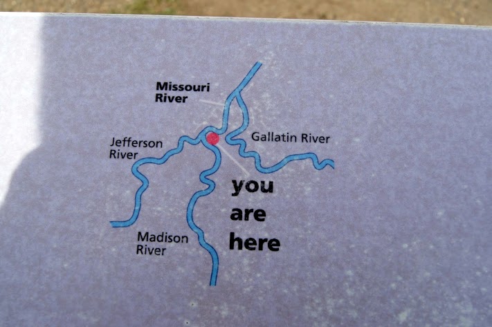
Missouri River Headwaters
The confluence of the Jefferson River, the Madison River, and the Gallatin River all combine to create the Missouri River. CaptainLewis described the scene pretty well when he wrote “the country opens suddenly to extensive and beautiful plains and meadows which appear to be surrounded in every direction with distant and lofty mountains.” This is also the location of Sacagawea’s capture and where she returned years later with Lewis and Clark. Additional information can be found at http://stateparks.mt.gov/missouri-headwaters/ N45.92616 W111.50306 Elevation 4663 feet [alpine-phototile-for-picasa-and-google-plus src=”user_album” uid=”117292386093793315084″ ualb=”5868721127277867505″ imgl=”fancybox” dltext=”Picasa” style=”floor” row=”4″ num=”150″ size=”220″ border=”1″ highlight=”1″ align=”center”...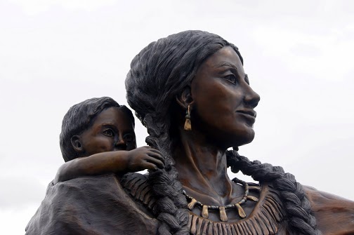
Twin Bridges, Montana
A small, remote Montana town that honors Sacagawea, Pompey, and Seaman. Small town park with a beautiful statute that includes Sacagawea, Pompey, and Seaman. The park also includes a 1/2 scale dugout canoe like the ones being used by the Corps. N45.54362 W112.33362 Elevation 3923 feet [alpine-phototile-for-picasa-and-google-plus src=”user_album” uid=”117292386093793315084″ ualb=”5868724264325057313″ imgl=”fancybox” dltext=”Picasa” style=”floor” row=”4″ num=”150″ size=”220″ border=”1″ highlight=”1″ align=”center”...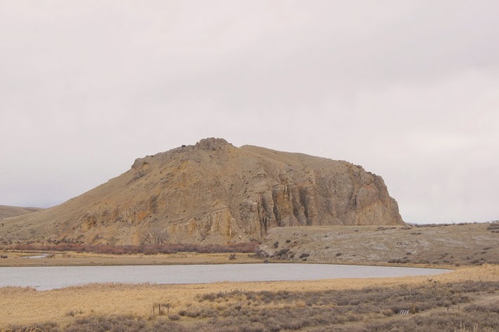
Beaverhead Rock
Sacagawea recognized the landmark and knew she was home. A significant landmark on the Missouri River was a signal that the Corps was nearing the home tribe of Sacagawea and the promise of horses for the rest of the journey. For really great detail and drama concerning Beaverhead Rock, check out the site http://www.nps.gov/nr/travel/lewisandclark/bea.htm N45.38620 W112.45306 elevation 4845 feet [alpine-phototile-for-picasa-and-google-plus src=”user_album” uid=”117292386093793315084″ ualb=”5868725092489525505″ imgl=”fancybox” dltext=”Picasa” style=”floor” row=”4″ num=”150″ size=”220″ border=”1″ highlight=”1″ align=”center”...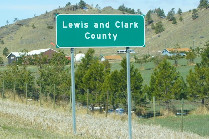
04-18-2013
After I entered the journal entries for yesterday, I had one more pretty cool adventure. As I was getting ready for bed about 10pm, I noticed that I was witnessing the very first clear sky of my trip. I just couldn’t resist an opportunity to see the sky better than I have ever seen it, on a totally clear, dark night with no ambient light in Montana. I dressed warm and headed out in my truck to get away from the lights of Great Falls. I finally found a “turn out” about 45 miles North of Great Falls and when I pulled in and shut off my lights, it was like being in a cave. There was absolutely no lights visible except the partial moon and a billion stars. Even the Milky Way welcomed me to the Big Sky country. It was truly an amazing sight. If you have never seen a totally dark sky, put that on your list. As my eyes adjusted to the darkness even better, I could see even more stars, probably about a billion and a half by now. It reminded me of the way the sky used to look when I was a young Boy Scout camping in the wilderness. Part of our routine was to lie flat on our backs and just gaze at the stars. OK, now about today. The mountains are beginning to be a more prominent feature in the days drive. I wonder how Lewis and Clark felt as they reached this point in their journey. They have to be accepting that these mountains are not like they ones they know about in Virginia and Tennessee. These were real mountains. ...
First Peoples Buffalo Jump
Buffalo jump? Who wouldn’t want to see that? Wow, now I understand what a buffalo jump is and it is not something I want to think about too much. This location is believed to be one of the main jump sites for several different tribes of natives over a few hundred years. Odometer reading 29,311 N47.48809 W111.53249 Elevation 3834 feet [alpine-phototile-for-picasa-and-google-plus src=”user_album” uid=”117292386093793315084″ ualb=”5868323792095101361″ imgl=”fancybox” dltext=”Picasa” style=”floor” row=”4″ num=”150″ size=”220″ border=”1″ highlight=”1″ align=”center”...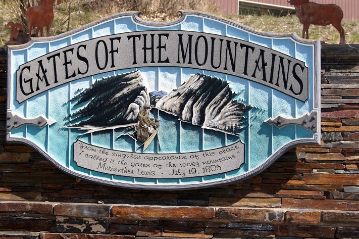
Gates of the Mountains
A beautiful lake nestled in the mountains and getting ready for spring tourist season. Since the season doesn’t actually start until May 1, the tour boats were not operational and no one was interested in assisting a wandering tourist like me. The lake is beautiful but the Lewis and Clark connection is the part called the “Gates” which is not visible except by boat. While visiting with a man that was launching his fishing boat, I casually asked if I could hire him to take me to the Gates. His reply was something like “the trout are really biting and you don’t have enough money for me to waste my time taking you for a boat ride”. Well, OK then, a good day to you too. I guess I really couldn’t blame him. I saw a few trout at the boat dock and they looked to be 16 to 20 inches long. odometer 29,382 N46.83177 W111.95298 Elevation 3612 [alpine-phototile-for-picasa-and-google-plus src=”user_album” uid=”117292386093793315084″ ualb=”5868330355014851425″ imgl=”fancybox” dltext=”Picasa” style=”floor” row=”4″ num=”150″ size=”220″ border=”1″ highlight=”1″ align=”center”...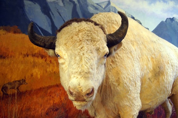
Helena, Montana
I took photos today in the House of Representatives in the Montana State Capitol Building. How cool is that? I visited the capitol building to see a very famous 25 foot mural related to Lewis and Clark. The mural is on the front wall of the Chambers for the House of Representatives and they were in session. When I explained my mission, I was allowed to enter the gallery and photograph the mural– NO FLASH and try not to disturb the session. I did exactly that. They had some kind of school drum team performing for them, how could a couple of photos disturb that? The Montana State Museum across the street from the capitol had numerous remarkable displays for only a $5 admission fee. I was not sure I wanted to pay until the young lady mentioned a “white buffalo”. I had to see that. Again, NO FLASH photography. The white buffalo is named “Big Medicine” in recognition of his symbolic importance to Native Americans. It is a beautiful specimen. odometer reading 29,404 N46.58680 W112.01602 Elevation 4149 feet [alpine-phototile-for-picasa-and-google-plus src=”user_album” uid=”117292386093793315084″ ualb=”5868333885523999073″ imgl=”fancybox” dltext=”Picasa” style=”floor” row=”4″ num=”150″ size=”220″ border=”1″ highlight=”1″ align=”center”...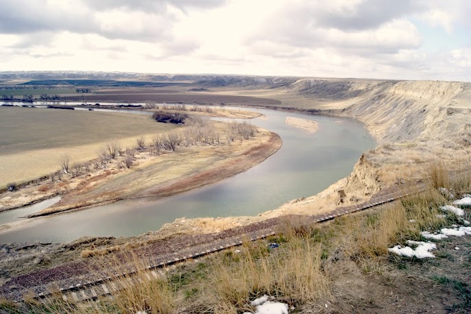
04-17-2013
The day started with about 4 inches of new snow from the night. If it’s not blizzard conditions, I am on my way. In Montana, 4 inches of new snow isn’t even worth talking about in April. I really enjoyed this day as the sites were a good variety, the roads were not too bad, and by the afternoon, the sun started to shine a little bit. You can see the transition in the photos as the day goes on. Daily data: Beginning odometer at Super 8 in Great Falls was 29060 miles. Ending odometer back at Super 8 in Great Falls is 29,211 miles. Meals for the day were $19.00 Lodging for the night was $69.00 + April 17,...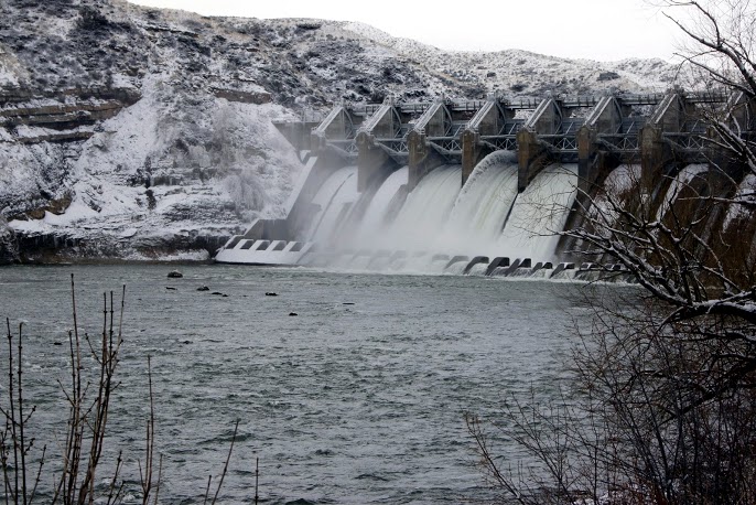
Great Falls
Lewis and Clark had been warned but they really didn’t know how bad it would be. Based on information provided by the tribes on the river, Lewis and Clark were anticipating the barrier of the falls. They knew they would have to portage and they were expecting that to add an extra day of hard work to get past the falls and back on the river. The falls were much greater than they expected and it ended up taking them an extra month to get around them. As you can see in the photos, the land surrounding the falls was not conducive to hauling the boats and all the cargo. The portage was described in the journals as being very tough, with steep hills, cactus tearing the mens moccasins, and the heat was unbearable—but the men did not complain. [alpine-phototile-for-picasa-and-google-plus src=”user_album” uid=”117292386093793315084″ ualb=”5867937521510664977″ imgl=”fancybox” dltext=”Picasa” style=”floor” row=”4″ num=”150″ size=”220″ border=”1″ highlight=”1″ align=”center”...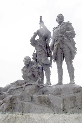
Fort Benton
This little Montana town is a very interesting, intriguing place out in the middle of nowhere. Known as the birthplace of Montana. So many interesting stories in this town and they have taken the trouble to share the stories with the wandering tourist. A drowned governor, Old Shep, the Grand Hotel, The bloodiest block in the West. Just some of the stories. For details about Old Shep, see http://www.fortbenton.com/shep/story.html. The town of Fort Benton has its own website also http://www.fortbenton.com/. N47.81676 W110.66817 Elevation 2637 feet [alpine-phototile-for-picasa-and-google-plus src=”user_album” uid=”117292386093793315084″ ualb=”5867943399162575089″ imgl=”fancybox” dltext=”Picasa” style=”floor” row=”4″ num=”150″ size=”220″ border=”1″ highlight=”1″ align=”center”...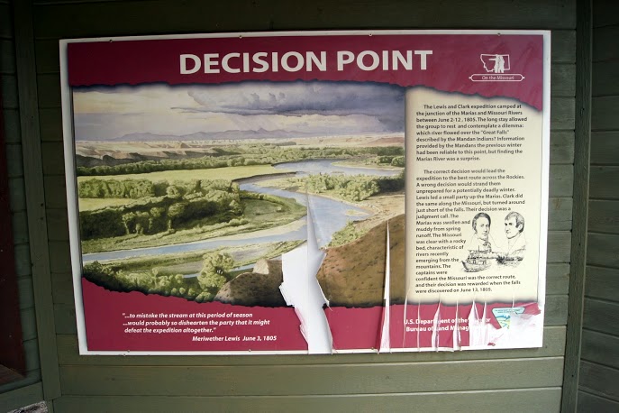
Decision Point
Should we take the left river or the right river ? The Corps camped here several days and scouted each of hte streams to make sure they were going the right way. A mistake at this point probably would have resulted in failure or even worse–being totally stranded in the Bitterroot Mountains for the hardest part of the winter. They had been warned about the upcoming great falls, but not about the river choice. The Captains split up and scouted each one and then decided the South stream seemed most likely to be the one leading to the great falls. They chose correctly and the mission continued. [alpine-phototile-for-picasa-and-google-plus src=”user_album” uid=”117292386093793315084″ ualb=”5867948587449576977″ imgl=”fancybox” dltext=”Picasa” style=”floor” row=”4″ num=”150″ size=”220″ border=”1″ highlight=”1″ align=”center”...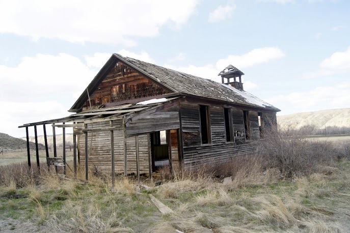
A fixer-upper ?
Spotted this off in the distance and just had to turn around and get a closer look. Looks like it may have been an old school or even a church. No signs of recent activity and no signs of critters living in it. Just an interesting site. Near Loma, Montana. N47.92003 W110.52641 Elevation 2591 feet [alpine-phototile-for-picasa-and-google-plus src=”user_album” uid=”117292386093793315084″ ualb=”5867956575430699345″ imgl=”fancybox” dltext=”Picasa” style=”floor” row=”4″ num=”150″ size=”220″ border=”1″ highlight=”1″ align=”center”...
04-16-2013
DETOUR—ROAD CLOSED–IMPASSABLE SNOW means do not go this way. My plan for the day was to drive to Fort Benton, Montana and visit some of the sites there and maybe end the day in Great Falls. Nature changed my plans again. I ended up driving straight to Great Falls and I will try to get to Fort Benton tomorrow. As it turned out, I was able to spend a couple hours at the Lewis and Clark National Historic Trail Interpretive Center in Great Falls. I am totally impressed with this facility and the staff that I met. It is the most complete, accurate, and well-kept center that I have seen so far. Their web site identifies them as the “Crown Jewel of the Lewis and Clark Trail” and I totally agree with that statement. Their web site is www.lewisandclarkfoundation.org. Be sure to look them up. You will learn a great deal about the Corps of Discovery through their displays. It is also a real asset in that you can look out the windows of the center and see the Missouri River and one of the falls. Today the view was a little obstructed by a blowing snow, but I am getting used to that. Their interpretive center takes the visitor from St. Charles, Missouri to Fort Clatsop and back to St. Charles. Extremely well done and aimed at elementary school children with a lot of hands-on displays. Their portrayal of the portage really demonstrates the struggles involved at that point of the journey. I am glad that my route was changed and that I had the extra time necessary to tour...
04-15-2013
My first impressions of Montana are beautiful and exciting. I have long imagined the Big Sky Country to be an impressive mix of mountains, grasslands, and rolling hills. In this first day of travel in Montana, I am seeing that I was on the right track with those expectations. The big sky has been full of snow and clouds so I have yet to see the expansive blue that is famous here. This is the 15th day of travel on this journey and the website has recorded well over 4600 views, which averages over 300 per day. To think that so many students are watching what I am doing is a bit intimidating. It drives me to do more and try harder to capture the adventure of Lewis and Clark and the Corps of Discovery. An early afternoon blizzard has caused me to bunker down a little early today, but I don’t expect to be stranded for days. I am spending the night in Lewistown, Montana. [alpine-phototile-for-picasa-and-google-plus src=”user_album” uid=”117292386093793315084″ ualb=”5867199262518646817″ imgl=”fancybox” dltext=”Picasa” style=”floor” row=”4″ num=”150″ size=”220″ border=”1″ highlight=”1″ align=”center”...
04-14-2013
Wow, it doesn’t get any better than this. I hope that intro got your attention. Overnight snow and a continuous snowfall all day makes travel unsafe. So, I have been sitting it out in Wolf Point, Montana. For those of you that don’t know right off the top of your head, Wolf Point is 75 miles West of North Dakota and 60 miles South of Saskatchewan. Surprisingly enough, spending two fun-filled nights alone in Wolf Point, Montana was not on my “bucket list”. This down time did give me a chance to do my laundry. Yeeehawwww ! Calm down a bit. It was an experience on its own. Picture this; 6 guys, all strangers to each other, doing their laundry at the only laundromat in town in blizzard conditions. Some of the strained conversations I overheard dealt with whether it is better to fold your underwear or roll them up; and how much bleach to use on these jeans. I made it a point to stay out of all that. Oh, by the way, if you ever need to find the laundromat here, it is behind the used car lot and there are no signs. Weather forecasts for tomorrow are vague at best, but it is going to have to be pretty bad out there to keep me in here. Thanks for following my...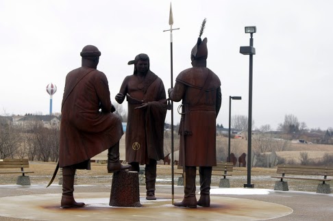
04-13-2013
Normally I would break this journal entry down into a few separate entries but….. I am just too tired to do that this time. It was a very long day and I am old you know. Started the day in Bismarck, North Dakota with a few photos of Sacagawea on the Capitol property. Next was a keelboat replica down by the Missouri River and a couple bridge photos. Then I went to Fort Mandan. This is where the expedition spent the first winter and where they met Sacagawea. Unexpectedly, the highlight of this stop was the statue of Seaman. A little larger than life-size, but very well done. Although the interpretive center was closed, I did get to wander through the replica of the fort. It seems strange to me that the interpretive center looked like it was open, there were a dozen cars in the parking lot, lights were on inside, but the doors were locked. There was no sign explaining that it was closed or why. Saturday morning within their posted open hours, but locked. My next stop was the North Dakota Lewis and Clark Interpretive Center in Washburn, North Dakota. Beautiful hilltop location just above the Missouri River. Elaborate well done displays, some interactive. The center is in the process of expanding with a new wing, but it doesn’t interfere with the existing displays. Very well done. Next in the photos you will see just a couple of oddities that I noticed during the day’s drive. My next stop was the Theodore Roosevelt National Park. This is one of the “best kept secrets” in our park system. I spent just over...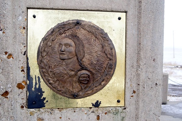
04-12-2013
Driving in the Dakotas today trying to make up the time lost by the Winter Storm Walda. The scenery in the Dakotas is amazing and varied. It is really an irony that when you see the snowy landscape it is so beautiful, but after driving 2 or 3 hours in it and it doesn’t change, it becomes boring. Actually stumbled across two monuments, one for Sitting Bull and one for Sakagawea. They are within 100 yards of each other on the banks of the Missouri River at one of its prettiest reservoirs, Lake Oahe near Mobridge, South Dakota. Neither of them have been very well maintained and they show signs of wear and abuse. I understand that the property is privately owned and not government supported, so that may be why they have deteriorated. These monuments are located at N45.51596 W100.48817, elevation 1800 ft. The question in my mind is, which state? North Dakota or South Dakota; I was thoroughly confused by the time I found them. More research for later. I have changed time zones back and forth between Central and Mountain time and I am not sure which zone I am in here in Bismarck, North Dakota. I guess it really doesn’t matter. Once in a while I will stop and take a picture of something (like the Bad River) and I really don’t know how it fits into the Lewis and Clark story other than a sign pointed me to it. I thought I had done a lot of research, but not enough for sure. I saw quite a few ring-necked pheasants today alongside the road but each time I tried to...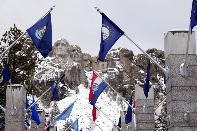
04-11-2013
The weather has eased up a bit and I finally got back on the road. When I left Chamberlain this morning, the roads were mostly snow covered but at least they were passable. As the morning went on the road conditions improved and I was able to travel my planned route for the day. The scenery with all the new snow was amazing. The whole countryside was pure white, bright and clean. Sunglasses were a must because of the glare. I planned two locations for the day, one was Mount Rushmore and the other was a drive through the Badlands. After completing them I saw a sign indicating a “Minuteman Missile Site” nearby. I couldn’t resist stopping to see this unusual item. None of these were Lewis and Clark related, but all three have significant history and/or geography. Daily data: Beginning odometer reading was 27,499. Ending odometer reading is 27,900 at Murdo, South Dakota Best Western Motel Meals were $26.00 (I had a buffalo chili dog for lunch and a buffalo ribeye for dinner). I paid $11.00 for parking at Mount Rushmore. Chamberlain, SD. The odometer was 27,499 and I bought 7.003 gallons @ $3.599 for a total of $25.20. The second fuel stop was at Rapid City, South Dakota. The odometer was 27,205 and I bought 13.002 gallons @ $3.369 for a total of $43.80. Lodging for the day is $68.34 + April 11,...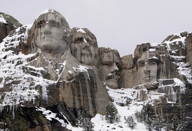
Mount Rushmore
If these guys are not Lewis and Clark, who are they and what are they doing on my trip? I know that Mount Rushmore and the Badlands are not usually associated with Lewis and Clark, but they are so significant in both history and geography and I was very near, I just had to visit them. I want you to enjoy the photographs AND learn a bit about them. First of all, who are those guys carved on the mountain? Which face was completed first ? Which one last? Since I am not assigning this as a homework problem, I will just give you the answers, but I still want you to learn them. The men are George Washington, Thomas Jefferson, Abraham Lincoln, and Theodore Roosevelt. Washington’s face was completed in 1930, Jefferson in 1936, Lincoln in 1937, and Roosevelt in 1939. For more information, you can visit their website http://www.nps.gov/moru/index.htm [alpine-phototile-for-picasa-and-google-plus src=”user_album” uid=”117292386093793315084″ ualb=”5865730648718014561″ imgl=”fancybox” dltext=”Picasa” style=”floor” row=”4″ num=”80″ size=”220″ border=”1″ highlight=”1″ align=”center”...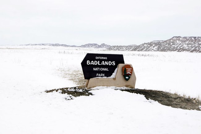
Black Hills and Badlands
The Southwest corner of South Dakota has some amazing history and geography. In another journal entry, you will see the historic Mount Rushmore. In this journal entry, you will see examples of the unique geography of the area. The best tutorial I have found on the Badlands is one produced by the National Park Service http://www.nps.gov/badl/photosmultimedia/badlands-in-brief.htm Today when I was there the Ranger told me that they received over 3 feet of snow in the last couple days and that is the most he can remember in his 20 years there. The snow really made it beautiful and unusual. I was lucky to get up close with several big horn sheep, so enjoy those photographs. [alpine-phototile-for-picasa-and-google-plus src=”user_album” uid=”117292386093793315084″ ualb=”5865734925377383633″ imgl=”fancybox” dltext=”Picasa” style=”floor” row=”4″ num=”80″ size=”220″ border=”1″ highlight=”1″ align=”center”...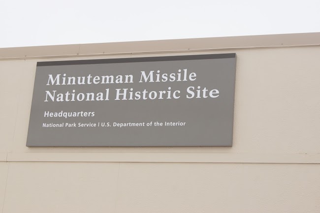
Minuteman Missile Site
Just a 30 minute missile flight from here to Moscow. In 1961 this Minuteman Missile Site was designed and built to be a substantial threat to our Cold War Enemy Russia. These missiles were intercontinental ballistic missiles with a capability of striking Moscow in less than 30 minutes from their silo in South Dakota. These particular missiles had a 1.2 megaton warhead, equivalent to over a million tons of dynamite. None of these missile silos remain active since the end of the Cold War. You may have to ask someone older to help you better understand what the Cold War was. [alpine-phototile-for-picasa-and-google-plus src=”user_album” uid=”117292386093793315084″ ualb=”5865751953616197761″ imgl=”fancybox” dltext=”Picasa” style=”floor” row=”4″ num=”80″ size=”220″ border=”1″ highlight=”1″ align=”center”...
04-10-2013
How long will this snow go on? Discussions around the coffee bar in the motel lobby this morning centered around how long will this continue and how much more snow are we going to get. Of course, none of the participants really knew the answers; they were all just like me: travelers from “somewhere else”. Each had their own story as to why they were here, where they were going, and why their situation was worse than the others. I felt a great deal of satisfaction in knowing that as much as I wanted to move on, I am not desperate to move on; it is not a critical issue for me. I can stay another day or two if necessary. Decision time! It seems to me that the southwest corner of South Dakota has the worst travel conditions; the area around Rapid City. The southwest corner of the state is also where I had planned to go as a “side trip” to inject some pretty significant “non Lewis and Clark” locations, such as The Badlands and Mt Rushmore. I am now thinking that if I wait here long enough for the southwest corner to clear up, I may not be able to adequately cover the remainder of the Lewis and Clark travels by May 1. I have not decided yet, but I am watching the conditions very closely to make the right decision. As of right now, I-90, the main East-West highway that would go to the Rapid City area, is closed by the highway patrol. They actually have gates at each onramp and the gates are closed and locked. They have been closed and locked...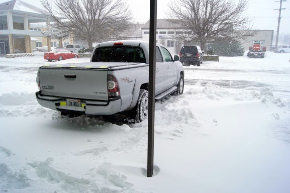
Winter Storm WALDA
OK Walda, you have my attention now! I felt brave enough this morning to venture out and see if conditions were good enough to travel. Watching the traffic go by the motel, everything seemed like it would be worth a try. I loaded up the truck and set out for at least another decision point. My goal for the drive would be to get to Chamberlain, South Dakota, which seemed to be a little larger community and may actually have motels (plural) and someplace to eat besides Subway. Three hours and 90 miles later, I arrived in Chamberlain and decided to make this my home for the duration of Walda. Some reports are saying Walda will be here through Thursday. In the photos, you can see that there is about 6 inches of snow here now and the estimates are about 24 inches. Local radio reports are now saying that the highway department is contemplating the closure of Interstate 90 in the next hour or so. [alpine-phototile-for-picasa-and-google-plus src=”user_album” uid=”117292386093793315084″ ualb=”5864892029323650641″ imgl=”fancybox” dltext=”Picasa” style=”floor” row=”4″ num=”80″ size=”220″ border=”1″ highlight=”1″ align=”center”...
It’s a SNOW DAY !!!!!
Freezing rain slamming against my motel room window woke me up about 3:30am this morning. Spent last night in Wagner, South Dakota which is South of Pierre. Road conditions are terrible now and only expected to get worse as the day goes on. Local forecasts for the next 24 hours are for an additional 2 feet of snow. In April? I expected to run into snow as I approached the Bitterroot Mountains, but not here in the plains. Depending on how long I am stranded here, I may have to alter some of my plans. I will just have to wait and see what happens. Since I have little else to do today, I will give you some homework. This has nothing to do with Lewis and Clark, but it is at least loosely related to history. Here is the assignment. The last time a U.S. President was assassinated was on my 19th birthday. When will I be 25,000 days old? Also, did you ever notice that my name backwards is Leon Revilo? What would yours be? I guess you can tell, it’s a SNOW DAY !!!!! CLICK HERE to contact me with your...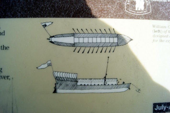
04-08-2013
Woke up to a dense fog this morning so I had a leisurely hotel-lobby-made waffle and several cups of pretty thick coffee. I am really starting to miss my own bed and my own….., well, I shouldn’t complain, this was my idea. The weather reports this morning are still warning of a major winter storm in the parts of the Dakotas that are in my immediate future. I was able to travel the whole day with little more than cloudy skies, quick blustery showers and one pretty impressive lightening strike at the Spirit Mound. This evening the weather reports are forecasting 18 inches to 24 inches with high winds and drifting for the next 24 to 48 hours. Lewis and Clark are getting even with me I think. All I can do is let the conditions dictate my travels. Had another correct answer today for the homework question on the photos with the spires. The person that answered today doesn’t get full credit because she failed to answer the second part of the question reference the source of the answer. Good job anyway. Start firing in some answers on today’s homework question. Have fun with it. See if your folks can help you with this one. I am hoping to venture off the Lewis and Clark trail for a bit and visit some other significant locations in South Dakota. I don’t want to give away all my secrets, so just wait and see what the weather allows. Daily data: Beginning odometer was 27, 196 miles at Vermillion, South Dakota. Ending odometer is 27,379 at Wagner, South Dakota. Bought fuel today...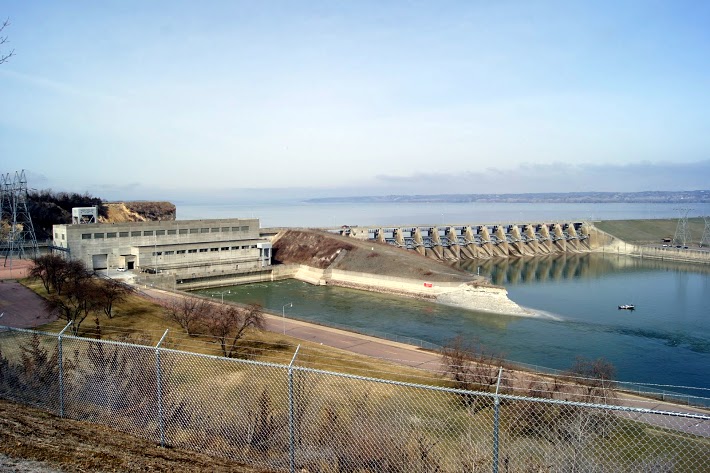
Gavins Point Dam
Gavins Point Dam is a hydroelectric dam on the Missouri River in the U.S. states of Nebraska and South Dakota. Built from 1952 to 1957, it impounds Lewis and Clark Lake. The dam is on the Nebraska-South Dakota border, west of Yankton, South Dakota. Gavins Point Dam is the lowermost dam on the Missouri, and was built as part of the Pick-Sloan Plan. The dam area (with Lewis and Clark Lake) is a very popular regional tourist destination. The next dam upstream is the Fort Randall Dam. The stretch of the Missouri immediately downstream of Gavins Point Dam is the only significant section of non-channelized meandering stream on the lower portion of the river. This federally designated Wild and Scenic River is among the last free-flowing stretches of the Missouri; it exhibits the islands, bars, chutes, and snags that once characterized the “Mighty Mo”. [alpine-phototile-for-picasa-and-google-plus src=”user_album” uid=”117292386093793315084″ ualb=”5864621877610599857″ imgl=”fancybox” dltext=”Picasa” style=”floor” row=”4″ num=”80″ size=”220″ border=”1″ highlight=”1″ align=”center” max=”100″] Content:...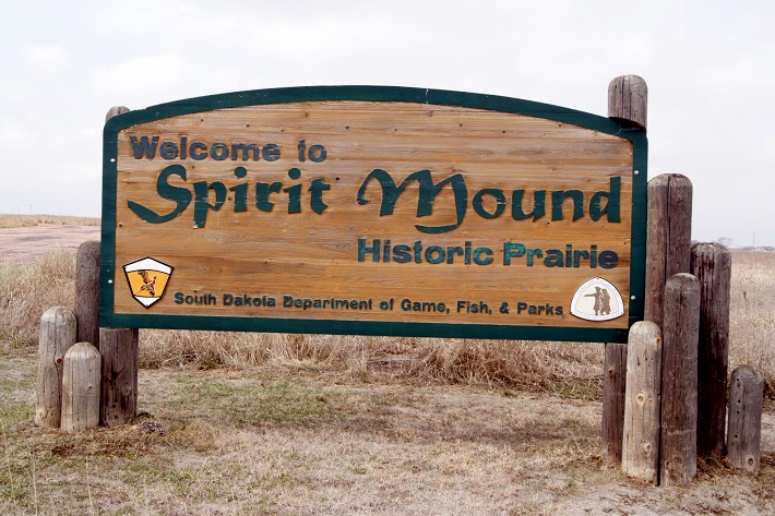
Spirit Mound
The Omaha, the Sioux, and the Otoes believe that the mound was occupied by spirits that killed any human who came near. Today when I visited the mound, there was a storm brewing nearby. As I walked toward the mound, the wind blew in my face almost as if it were pushing me away. I took a couple photos anyway. The sky continued to darken and a brilliant bolt of lightening cracked in the West. Enough for me. Spirit Mound? I hurried back to my truck with a few distant photos. That will have to do for today. On August 24, 1804, the day before they reached the mouth of the Vermillion, which they called the White Stone River, Clark wrote: “Capt Lewis and my Self Concluded to visit a High Hill Situated in an emence Plain three Leagues N. 20º W. from the mouth of White Stone river, this hill appear to be of a Conic form and by all the different Nations in this quater is Supposed to be a place of Deavels or that they are in human form with remarkable large heads and about 18 inches high; that they are very watchfull and ar armed with Sharp arrows with which they can kill at a great distance; they are said to kill all persons who are so hardy as to attemp to approach the hill; they state that tradition informs them than many indians have suffered by these little people and among others that three Maha men fell a sacrefice to their murcyless fury not meany years since- so much do the Mahas Souix Ottoes and other neibhbouring nations...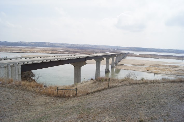
Chief Standing Bear Memorial Bridge
A beautiful, modern bridge over a particularly wide Missouri River valley. Chief Standing Bear was a Ponca Native American chief who successfully argued in U.S. District Court in 1879 in Omaha that Native Americans are “persons within the meaning of the law” and have the right of habeas corpus. His wife Susette Primeau was also a signatory on the 1879 writ that initiated the famous court case. N42.84948 W97.47814 Elevation 1237 feet [alpine-phototile-for-picasa-and-google-plus src=”user_album” uid=”117292386093793315084″ ualb=”5864626652628133697″ imgl=”fancybox” dltext=”Picasa” style=”floor” row=”4″ num=”80″ size=”220″ border=”1″ highlight=”1″ align=”center” max=”100″] Content:...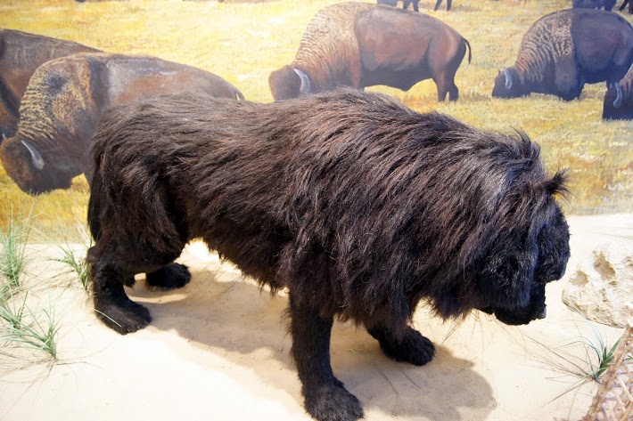
04-07-2013
A rainy morning in Nebraska. A good time to do my laundry. Woke up at my usual time, saw it was raining and went back to sleep until 7am. That felt pretty good. It has been a long, active but exciting first week of the journey. Each day I am getting emails from students, friends, and even total strangers that have somehow heard about the website and my journey. Everyone is very encouraging and enthusiastic. Thank you so much. Tonight, I am sitting in a motel room in Vermillion, South Dakota and watching the weather channel because of some pending problems. Something called Winter Storm Walda. Whatever that is. It seems that over the next 2 or 3 days I will be facing at least 8 inches of new snow and possibly double that. My plan is to keep a watchful eye on the weather, play it safe and possibly find a motel that will suit me while I sit out “Walda’. I have promised my wife that I will “BE CAREFUL” and I will do that. My schedule is flexible so I can sit it out if I need to. Daily data: Beginning odometer was 27,035 at Omaha, Nebraska Ending odometer is 27,196 at Vermillion, South Dakota Best Western. Meals cost for the day is $17. Lodging cost for the night is $86.79. There was a $1.00 bridge toll Spent $6.00 for laundry. + April 07,...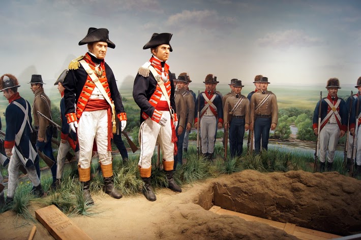
Sioux City Lewis and Clark Interpretive Center
This is a private, non-profit cultural complex on the Missouri Riverfront. The beautiful center opened in 2002 in time to commemorate the Lewis and Clark Bicentennial in 2004. It expanded even further in 2007 to include an “Encounter Center”. The original wing is dedicated to Lewis and Clark and has some very unique displays that I thoroughly enjoyed. One is an animated Seaman barking at a prairie dog. The other is a very dramatic burial ceremony for Sgt. Floyd which includes Lewis and Clark paying tribute to their friend and fellow soldier. To think that this facility is privately funded and non-profit is almost unbelievable. Very well done and my thanks to the Missouri River Historical Development, Inc. Visit their website at siouxcitylcic.com [alpine-phototile-for-picasa-and-google-plus src=”user_album” uid=”117292386093793315084″ ualb=”5864255302497275185″ imgl=”fancybox” dltext=”Picasa” style=”floor” row=”4″ num=”80″ size=”220″ border=”1″ highlight=”1″ align=”center”...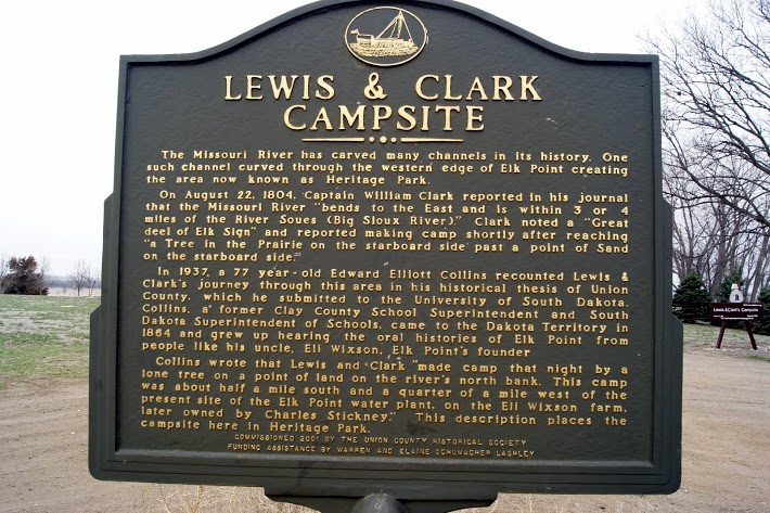
Elk Point, South Dakota
By seeing a small sign on the side of the road indicating a Lewis and Clark Historic Marker, I decided to follow the signs. They led me into a very small town named Elk Point in South Dakota. The signs led through the two block downtown and into a city park with ball diamonds and a small pond. At the end of the circle drive in the park I saw the two signs. No big monuments or structures full of artifacts, just a small town that is proud of the fact that lewis and Clark camped there. I think I would be proud too. [alpine-phototile-for-picasa-and-google-plus src=”user_album” uid=”117292386093793315084″ ualb=”5864253877280483841″ imgl=”fancybox” dltext=”Picasa” style=”floor” row=”4″ num=”80″ size=”220″ border=”1″ highlight=”1″ align=”center”...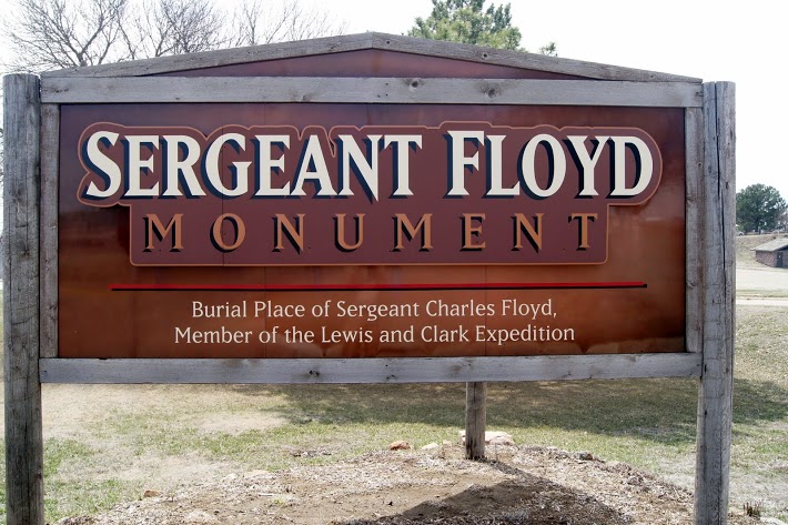
Sgt. Floyd’s Monument
This memorial marks the grave of the only member of the Lewis and Clark Expedition to die during the historic journey. Sergeant Charles Floyd was a young man from Kentucky and he kept a journal on the expedition for ninety-nine days until he died on August 20, 1804, near the present day Sioux City, Iowa. On the afternoon of August 20, 1804, Corps of Discovery soldiers accorded their deceased comrade all the honors of war. All the soldiers were in full dress uniform for the burial high on a “handsome spot on the bluff” overlooking the Missouri River. The monument is a 100 foot sandstone obelisk and it was dedicated in 1901. In 1960 it became the first National Historic Landmark registered by the Natinoal park Service and U.S. Department of Interior. [alpine-phototile-for-picasa-and-google-plus src=”user_album” uid=”117292386093793315084″ ualb=”5864237548225712737″ imgl=”fancybox” dltext=”Picasa” style=”floor” row=”4″ num=”80″ size=”220″ border=”1″ highlight=”1″ align=”center”...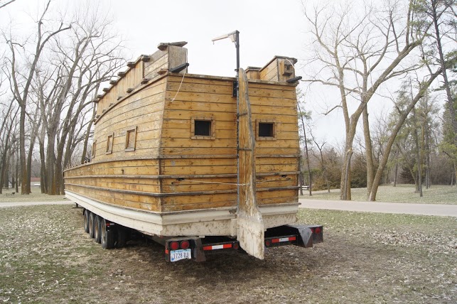
Lewis and Clark Park, Onawa, Iowa
Full size replica of the keel boat used by the Corps of Discovery. Fifty-five feet long and about 8 1/2 feet wide. The Corps took this boat as far upstream as possible and as you will find out later in the adventure, they sent it back downstream. This park was totally empty– I was the only human there___. Maybe that is because of the time of year, but all the buildings were locked up and dark. I have heard that during the summer, the keel boat is put into the water here and gives short rides. Sure no sign of such activity now. [alpine-phototile-for-picasa-and-google-plus src=”user_album” uid=”117292386093793315084″ ualb=”5864236892074472417″ imgl=”fancybox” dltext=”Picasa” style=”floor” row=”4″ num=”80″ size=”220″ border=”1″ highlight=”1″ align=”center”...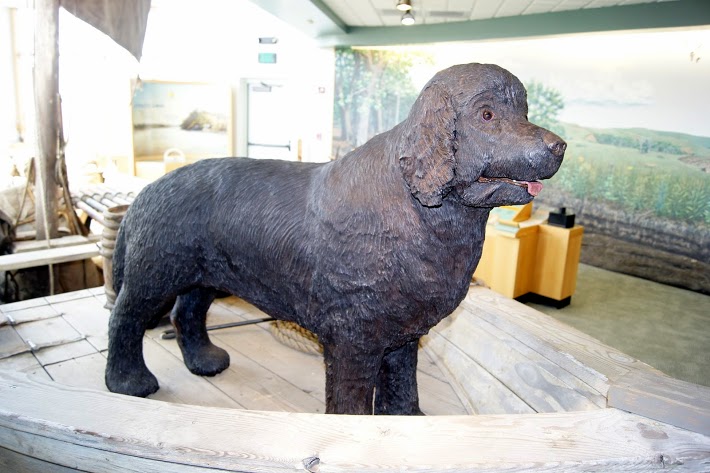
04-06-2013
I spent a great 1/2 day + at my first stop, the visitor center at Nebraska City. I was able to find just the right mixture of indoor museum pieces and outdoor trail hiking to make a really refreshing, informative start for the day. Three levels of exhibits included some sophisticated displays of “fishing techniques” and first edition stamps and some hands-on displays for elementary students. Of course the displays of bears and other critters was the best I have seen so far on this trip. My next stop was to see the confluence of the Missouri River and the Platte River. I was disappointed that I never did get to see the actual confluence of the two rivers. I drove several miles on paths that used to be gravel and followed hand-made signs and eventually made it to the banks of the Platte River, but I could not get to the Missouri River. It appeared to me that some recent flooding may have destroyed the path/roadway to the actual confluence. Daily data: beginning odometer was 26,929 miles Ending odometer at Omaha Comfort Inn is 27,035 miles Loding for the night is $82.88 There was one bridge toll of $1.25. No fuel purchased today. + April 06,...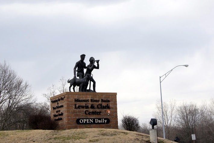
Missouri River Basin Lewis and Clark Trail Visitor Center
This is a beautiful, very well maintained, multifaceted facility that is a “must see” for Lewis and Clark buffs. Perfectly situated high above the Missouri River at Nebraska City, Nebraska, this facility has been able to combine many aspects of the Corps of Discovery. I think it is appropriate for the casual visitor that knows little or nothing about the great adventure, and it is appropriate for the well prepared student of Lewis and Clark. Each extreme will be able to absorb something of significance from this facility and its intriguing grounds. I had a short visit here on one evening just before they were closing for the day and an extended visit the next day. In both instances, the staff at the facility were more than cordial, very enthusiastic and knowledgable, and eager to ensure that my visit was a rewarding one. They were rightfully proud of their facility and they were determined to show it at its best. You might want to check out their web site too. CLICK HERE [alpine-phototile-for-picasa-and-google-plus src=”user_album” uid=”117292386093793315084″ ualb=”5863884262482926705″ imgl=”fancybox” dltext=”Picasa” style=”floor” row=”4″ num=”80″ size=”220″ border=”1″ highlight=”1″ align=”center”...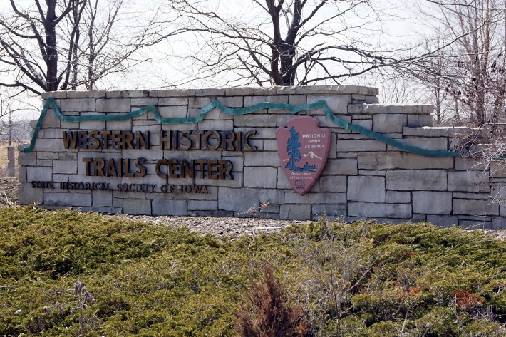
Western Historic Trails Center
A visitors center aimed at drawing attention to all of the historic trails. Displays feature mock-up scenes from the Sante Fe Trail, the Oregon Trail, the Mormon Trail, the Lewis and Clark Trail, etc. To quote from one of the displays “The trails are about people… the pioneers who crossed the trails, the reasons for their crossings and the people who aided, or impeded their journeys.” N41.22788 W95.90059 Elevation 980 feet [alpine-phototile-for-picasa-and-google-plus src=”user_album” uid=”117292386093793315084″ ualb=”5863890906757454817″ imgl=”fancybox” dltext=”Picasa” style=”floor” row=”4″ num=”75″ size=”220″ border=”1″ highlight=”1″ align=”center”...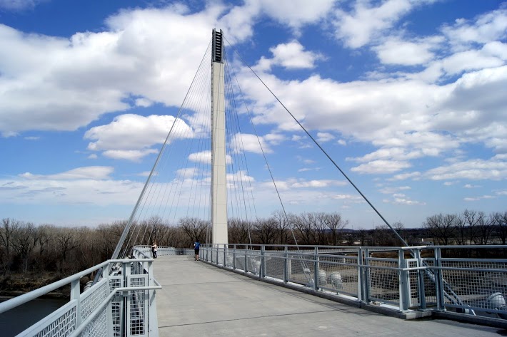
Bob Kerry Pedestrian Bridge
A beautiful, modern pedestrian and bicycle bridge over the Missouri River between Omaha, Nebraska and Council Bluffs, Iowa. Pedestrian pathways and this bridge really accent the downtown riverfront of Omaha. On this Saturday afternoon, there was more bicycle and pedestrian traffic downtown than vehicle traffic. I planned to visit the Lewis and Clark display in the visitor’s center of the National Park Service regional office, which is located in the middle of the bustling downtown area; but THEY ARE CLOSED ON SATURDAY AND SUNDAY! Does that make any sense to you ? This visitor center sits at the West end of the pedestrian bridge and there were hundreds of people walking past the front doors of the building. We sure wouldn’t want any of them to wander in on the weekend. ‘Nuff said. [alpine-phototile-for-picasa-and-google-plus src=”user_album” uid=”117292386093793315084″ ualb=”5863892328176400401″ imgl=”fancybox” dltext=”Picasa” style=”floor” row=”4″ num=”75″ size=”220″ border=”1″ highlight=”1″ align=”center”...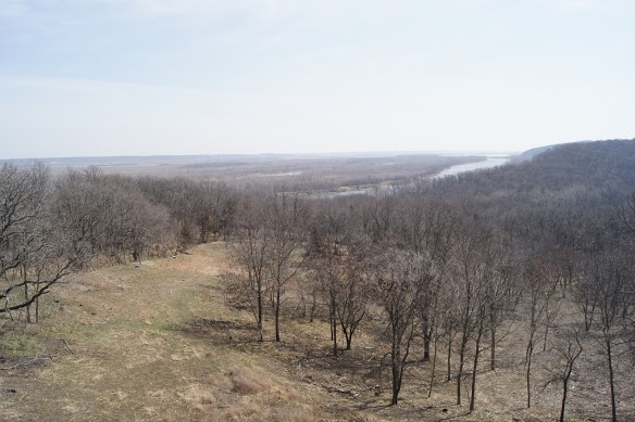
04-05-2013
The Missouri River is the boundary between Kansas, Nebraska, Missouri, and Iowa so it is hard to tell just where you are. Today’s travels started in Kansas and ended in Nebraska, but state lines where crossed a couple different times. Even as I look out hte window, the scenery is so similar, it is difficult to tell which state you are in. It makes me realize that the boundaries are pretty much artificial and probably just a tool for government use. As today came near an end, I had a brief visit at a place that appears to be a real treasure for someone seeking a Lewis and Clark experience like I am. The place is the “Missouri River Basin Lewis & Clark Interpretive Trail and Visitor Center”. The Center is located in Nebraska City, Nebraska right on the West bank of hte Missouri River. I am staying at Nebraska City tonight and planning to spend most of tomorrow at the Center. Today’s data: Beginning odometer was 26,756 miles. Ending odometer is 26,929 miles. Bought fuel at Auburn, Nebraska, 13.374 gallons @ $3.499 for a total of $46.80 Meals cost $14.00 Lodging at Best Western for $77.57 + April 05,...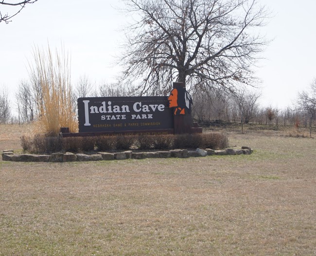
Indian Cave State Park
Beautiful park with a variety of attractions situated on the banks of the Missouri River. Beautiful vistas of the Missouri River are combined with gently rolling hills and limestone cliffs, all within a very well maintained state park. A tour of this park is worth far more than the $5 day pass. The unique one way paved roadway leads through some beautiful valleys of mature trees and meadows. An occasional peak at the river through the trees makes me think about the Natives observing Lewis and Clark as they struggled up the river. It would have been very easy to observe the Corps without being detected just a few feet from the water. The petroglyphs in the limestone are a real treasure to see. I can only imagine when and why the Natives would have devoted the time and effort to leave this artwork. [alpine-phototile-for-picasa-and-google-plus src=”user_album” uid=”117292386093793315084″ ualb=”5863513590416389201″ imgl=”fancybox” dltext=”Picasa” style=”floor” row=”4″ num=”75″ size=”220″ border=”1″ highlight=”1″ align=”center”...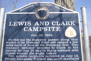
Rulu, Nebraska
Lewis and Clarke Campsite. [alpine-phototile-for-picasa-and-google-plus src=”user_album” uid=”117292386093793315084″ ualb=”5863507615165308257″ imgl=”fancybox” dltext=”Picasa” style=”floor” row=”4″ num=”75″ size=”220″ border=”1″ highlight=”1″ align=”center”...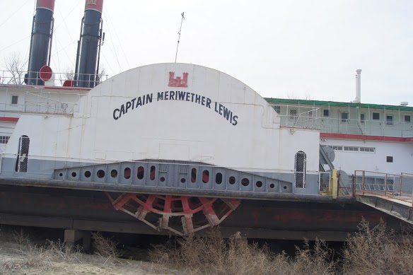
Captain Lewis Paddle Wheeler
Captain Meriwether Lewis paddle wheeler weathering on the banks of the Missouri River. On the West bank of the Missouri River at Brownville, Nebraska there sits an old paddlewheeler dredge ship. It is safely situated on a “dry dock” It was very interesting to see the huge paddle wheels on each side and the gigantic dredging equipment on the bow. Markings indicate the ship is owned by the U.S. Army Corps of Engineers. [alpine-phototile-for-picasa-and-google-plus src=”user_album” uid=”117292386093793315084″ ualb=”5863519250135337249″ imgl=”fancybox” dltext=”Picasa” style=”floor” row=”4″ num=”75″ size=”220″ border=”1″ highlight=”1″ align=”center”...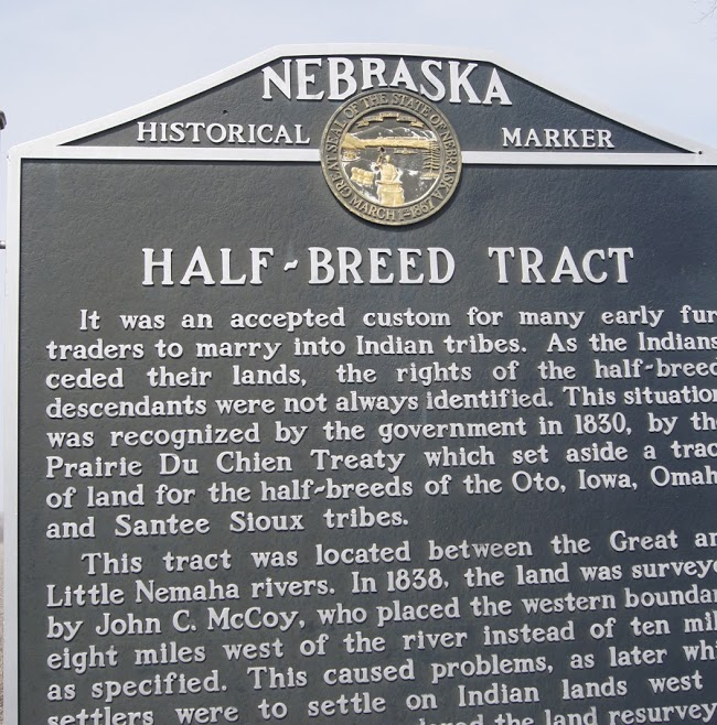
Half-breed tract ?
Half-breed sounds like a derogatory term, but it describes a common situation in our history with the Native Americans. This is a roadside marker that caught my attention, both by the unusual term and that it is a part of our history. The sign is on US 136 in Eastern Nebraska. N40.39275 W95.82182 Elevation 925 feet [alpine-phototile-for-picasa-and-google-plus src=”user_album” uid=”117292386093793315084″ ualb=”5863521214659697089″ imgl=”fancybox” dltext=”Picasa” style=”floor” row=”4″ num=”75″ size=”220″ border=”1″ highlight=”1″ align=”center”...
04-04-2013
Thank you Missouri for all the great Lewis and Clark sites. Now it’s time to head in a more northerly direction in Kansas. Still following the Missouri River for a rather short trip in Kansas before we travel into Nebraska/Iowa. Each time I stop to buy fuel, I remind myself of the generosity of the Macomb Rotary Foundation and my State Farm Insurance Agent Cathy Early. They both made a generous donation to my fuel fund for this trip and I really appreciate it. Daily data: Starting odometer reading at Independence, Missouri was 26,635. Fuel purchased at Independence 11.801 gallons @ $3.299 for a total of $38.93 Admission fee for Arabia $15.00 Ending odometer reading at Atchison, Kansas is 26,755 Meals for the day cost $16.00 Lodging at Super 8 is $73.42 + April 04,...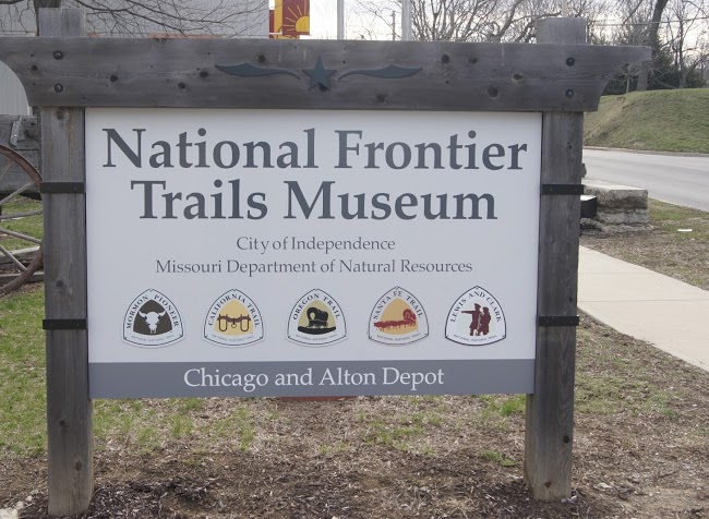
National Frontier Trails Museum
Not just the Lewis and Clark Trail. Great exhibits on the other major Trails of our history. Sante Fe, Oregon, and California trails are all important events in our history and each has its own story. I think each of them could be a future adventure for some of you that are following this blog. [alpine-phototile-for-picasa-and-google-plus src=”user_album” uid=”117292386093793315084″ ualb=”5863137165478882673″ imgl=”fancybox” dltext=”Picasa” style=”floor” row=”4″ num=”75″ size=”220″ border=”1″ highlight=”1″ align=”center”...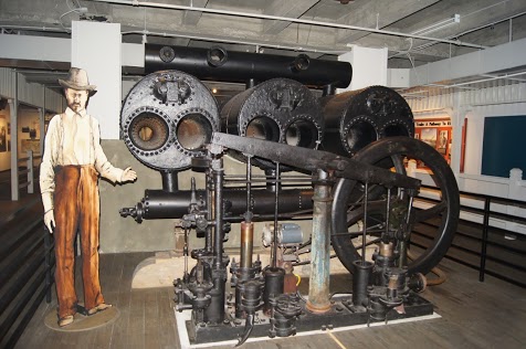
ARABIA Steamboat
A beautiful Missouri River steamboat named Arabia remained sunk for 132 years before being located and recovered. It’s a great story about how the ship was located more than a half mile from the Missouri River after more than a century of being buried in the mud and silt. The complete story can be found at http://1856.com/. [alpine-phototile-for-picasa-and-google-plus src=”user_album” uid=”117292386093793315084″ ualb=”5863140120011523585″ imgl=”fancybox” dltext=”Picasa” style=”floor” row=”4″ num=”75″ size=”220″ border=”1″ highlight=”1″ align=”center”...
Northwest Missouri Locations
Lewis and Clark Historical Marker. How many of those signs have they put out? It seems like every few miles, there is another sign indicating a “Lewis and Clark Historical Marker”. Initially, I was checking out each one, following the arrows, and finally getting to the location. Sometimes it was not possible to actually locate the site mentioned, other times the site was a real disappointment. BUT, I still can’t just ignore the sign; I have to at least try to check it out. So please bear with me if some of the photos are less than you might otherwise expect. [alpine-phototile-for-picasa-and-google-plus src=”user_album” uid=”117292386093793315084″ ualb=”5863141679705303521″ imgl=”fancybox” dltext=”Picasa” style=”floor” row=”4″ num=”75″ size=”220″ border=”1″ highlight=”1″ align=”center”...
04-03-2013
The third day into my journey and I am very quickly learning that I need to slow down a bit. Most of my entire life has been pretty scheduled and organized and I am most comfortable under those circumstances. I am learning that this trip is not going to be all that organized and scheduled. I really have to make myself slow down, let the circumstances dictate the pace, stay a little longer if more time is needed, and don’t feel the need to rush off to the next mark on my map. Today is a good example of that. I just could not leave Lexington as I had planned. It deserved more time, more walking around, more study, and more investment than I had planned. Maybe over the next few weeks, I will come across some places that will go fairly quickly and I can make up the time; but I’m not sure about that. I am sure that I will not hurry and I will absorb all that I can, and I will enjoy each step. This has been a life-long desire of mine, so why hurry. Data for the day: Beginning odometer at Richmond, Mo 26,559 Ending odometer at Independence, Mo 26,635 Drury Inn, Independence, MO N39.05326 W94.47480 899 ft 50 degrees F. Lodging costs $102.00 (includes evening meal and breakfast tomorrow) Lunch $8.00 Entry fee at Fort Osage $3.00 + April 03,...
Lexington, MO
More history than I could absorb in a day. This is a place that I will have to revisit some day when I can be better prepared to understand the complexities of the 19th century in this part of Missouri. Who knew that there was a “Battle of Lexington” in the Civil War? I always thought the Battle of Lexington was a revolutionary war battle. Well, it was that too, but this one is in Missouri and involves “HEMP”. Not the marijuana type that we know of today. The confederates used the river soaked hemp bales to protect them as they advanced on the union soldiers on the third day of battle in Lexington. This strategy forced the union soldiers to surrender and forfeit the territory. Additional stories of Lexington in the 1800’s are too numerous and involved for me to begin to discuss here. If you are interested, do some research about Lexington, Missouri. N39.18553 W93.88286 872 ft [alpine-phototile-for-picasa-and-google-plus src=”user_album” uid=”117292386093793315084″ ualb=”5862761675920024449″ imgl=”fancybox” dltext=”Picasa” style=”floor” row=”4″ num=”75″ size=”220″ border=”1″ highlight=”1″ align=”center”...
Napolean, MO
I saw a sign on the highway that indicated a “Lewis and Clark historic place”, so I turned off the main path. After driving about 4 miles and wondering if I missed other signs, I finally came to a small Missouri River town of Napolean. On the riverbank there was a small marker indicating that Lewis and Clark had camped there on their westward journey. N39.13217 W94.06961 760 ft [alpine-phototile-for-picasa-and-google-plus src=”user_album” uid=”117292386093793315084″ ualb=”5862768871657761873″ imgl=”fancybox” dltext=”Picasa” style=”floor” row=”4″ num=”50″ size=”220″ border=”1″ highlight=”1″ align=”center”...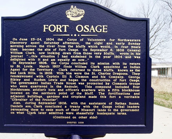
Fort Osage, MO
After the epic journey, Captain Clark continues to serve his President. Under the direction of William Clark and Captain Eli B. Clemson, soldiers erected Fort Osage in 1808 to serve as an outpost for the newly established Louisiana Purchase. It housed soldiers assigned to guard the new territory. The fort also offered Missouri’s early settlers and explorers a sanctuary from which to venture westward. N39.18594 W94.19367 899 ft [alpine-phototile-for-picasa-and-google-plus src=”user_album” uid=”117292386093793315084″ ualb=”5862769806129572481″ imgl=”fancybox” dltext=”Picasa” style=”floor” row=”4″ num=”50″ size=”220″ border=”1″ highlight=”1″ align=”center”...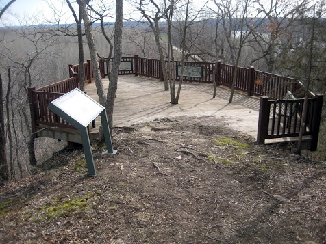
Panoramic Photo at Clark’s Hill, Missouri
Just imagine Captain Clark standing on top of this hill and looking around, seeing both the Missouri and the Osage Rivers.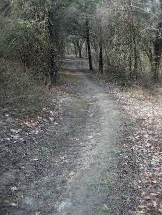
04-02-2013
Today was a little different than yesterday. I was only able to visit two sites today because both of them involved some rather long hikes and then a considerable drive between them. The first site is Clark’s Hill. This is a location noted in Captain Clark’s journal. Captain Clark notes that on June 2, 1804, he climbed the hill at this point to observe the confluence of the Osage River and the Missouri River and the surrounding countryside. From what I could see today, he climbed a nearly vertical hill for about 200 feet. My climb today was not that steep, but it was almost a mile and it was up and down hill on a marked path. It was a comfortably cool day and there was no one else within miles. The beauty of the scenery and the sounds of nature combined to keep a smile on my face the whole time I was there. The second site is Arrow Rock State Park. A very beautiful state park with very nice roads and pathways and streams. I am not aware that it is historically significant to the Lewis and Clark era, but it does have a preserved pioneer village that would be worth a visit at some point in the future. Yesterday, I mentioned an artist named Gary Lucy but I forgot to include his web site. It is garylucy.com Be sure to check the section called “prints”. They are amazing. Data for the Day: Bought fuel at Columbia, MO. 11.493 gal @ $3.539 for a total of $40.67. N38.96633 W92.33288 735 feet 42 degrees F. Food costs for the day are...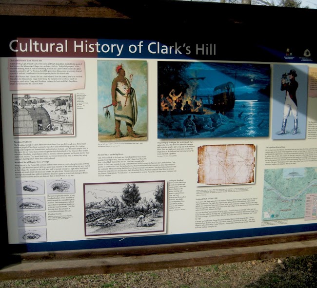
Clark’s Hill
A very beautiful hike along a marked trail leads to a rewarding view of the confluence of the Osage River and the Missouri River and the surrounding countryside. N 38.56126 W 92.02237 737 ft on the viewing platform 595 ft estimated river level at that location [alpine-phototile-for-picasa-and-google-plus src=”user_album” uid=”117292386093793315084″ ualb=”5862377262418208993″ imgl=”fancybox” dltext=”Picasa” style=”floor” row=”4″ num=”50″ size=”220″ border=”1″ highlight=”1″ align=”center”...Arrow Rock State Park
Rolling hills with open meadows, dense woods and spring fed streams. N 39.06697 W 92.94097 695 feet 45 degrees F. Nice, scenic hiking with a preserved pioneer village. [alpine-phototile-for-picasa-and-google-plus src=”user_album” uid=”117292386093793315084″ ualb=”5862402518364099265″ imgl=”fancybox” dltext=”Picasa” style=”floor” row=”4″ num=”50″ size=”220″ border=”1″ highlight=”1″ align=”center”...
Panoramic Photo at Confluence Point, Missouri
Viewing to the South, the river on the left is the Mississippi and the river on the right is the Missouri.
04-01-2013 Finally on the road!
First stop was Casey’s in Colchester, IL to fill the fuel tank. As you can see on the whiteboard, the odometer reading at the beginning of the trip is 25,961 miles. Next stop was to view the Lewis and Clark Bridge at Alton, IL. N 38.88809 W 90.17739 Elevation 452 feet. Odometer 26,098 Jones Confluence State Park. This is where the Mississippi River and the Missouri River join. Included 10 miles of driving on a gravel road. 46 degrees. Washington, Missouri and the Gary Lucy Gallery. Gary Lucy is the best Lewis and Clark artists that I have found. His gallery is two blocks from the Missouri River. Daniel Boone Burial Site. Although Daniel Boone had nothing to do with Lewis and Clark, he was an important pioneer; so important that Lewis and Clark paid tribute to him when they passed his home area on the Missouri River. N 38.62156 W 91.03459 Elevation 469 feet. 50 degrees F. Data for the day: Bought fuel at Warrenton, Missouri. Odometer reading was 26,212. Bought 11.75 gallons at $3.549 per gallon. Meals cost me $14.00 for the day. I had quite a few snacks that I brought from home. Stopped for the night at Booneville, Missouri. The room costs $49.01. The odometer is 26,304. It is 48 degrees F. + April 01, 2013 [alpine-phototile-for-picasa-and-google-plus src=”user_album” uid=”117292386093793315084″ ualb=”5862011222832535793″ imgl=”fancybox” dltext=”Picasa” style=”floor” row=”4″ num=”50″ size=”220″ border=”1″ highlight=”1″ align=”center”...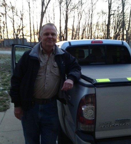
The Journey Has Begun
7:22 AM getting ready to depart on the trip. Follow along on the website and twitter every day for updates, photos and videos from the...
Apollo School Presentation
Here is the presentation given at the Apollo School by my Dutch friend, Christiaan Davids. Christiaan was an exchange student that lived with us in Colchester for a full year about 20 years ago. I thought it would be fun for you to see how he is presenting the Lewis and Clark project to the Dutch students. It is even fun to see the text in a foreign language. As you can see, he has included some photographs from Colchester in his presentation so the students will better understand where he attended school in the U.S.A. Click Here to View and Download this...
03-27-2013 State Farm Agent Cathy Early Supports the Project
State Farm Agent Cathy Early of Macomb has made a significant monetary contribution in support of the Lewis and Clark Project. Her contribution demonstrates her community involvement and commitment especially as it relates to education. Thank you for your support Cathy, and yes you can be sure that I will be wearing my seatbelt and I will drive...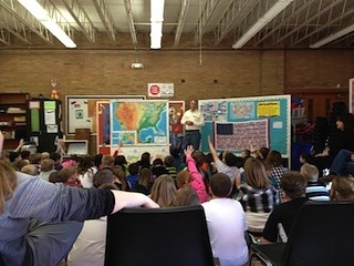
03-27-2013 80+ Elementary Students at West Prairie South
More than 80 second, third, and fourth grade students assembled this afternoon to be briefed on the Lewis and Clark trip that begins next Monday. They clearly showed their curiosity by asking questions ranging from “How old are you?” to “How many animals did they discover?” It was clear that they have been studying in preparation of the journey and they already know a great deal about it. When I told them I have personally interviewed both Lewis and Clark, they quickly and unanimously challenged the truth of the statement. Pretty sharp kids. I really enjoyed visiting with them and seeing their...
03-25-2013 Only one week to finish preparation
Next Monday, April 1, 2013, I will be on my way. A lot of new snow here over this last weekend and I am busy preparing to begin the trip. I had all my “winter” clothing packed and loaded in the truck but had to get some of it out to deal with the snow here at home. Some followers have been having trouble with the latitude/longitude homework assignment and some of that problem was my fault. I have since changed the syntax of the coordinates I provided. Give it another try with the new coordinates and let me know if it works any better or not. I want followers to be able to utilize lat/long coordinates so let’s keep working with it until I get it right. I had a school “assembly” scheduled this afternoon, but all the local schools are closed today due to the weather. Hopefully, I can get it rescheduled in the next couple days. For those of you that haven’t already done so, send me an email and tell me who you are, where you are, and how you might be using the blog. I want to hear from each of you so I can have a feel for who is watching and following. Also, if you have any suggestions for improvements, let me...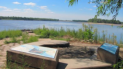
Confluence Point State Park
Visitors can still witness the 2 rivers as they merge at this 1,118-acre park located on the north side of the Missouri River at its confluence with the Mississippi River north of St. Louis. WHERE TWO RIVERS BECOME ONE In 1721, French explorer, Father Pierre Francois de Charlevoix, wrote of the confluence of the Mississippi and Missouri Rivers, “I believe this is the finest confluence in the world. The two rivers are much the same breadth, each about half a league: but the Missouri is by for the most rapid, and seems to enter the Mississippi like a conqueror, through which it carries its white waters to the opposite shore without mixing them, afterwards, it gives its color to the Mississippi which it never loses again but carries quite down to the sea …” Photo: GreatRiverRoad.com ...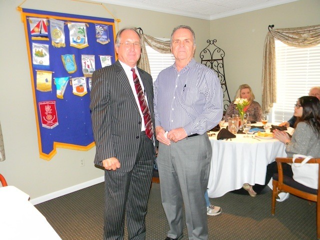
03-20-2013 Macomb Rotary Supports the Effort
The Macomb Rotary Foundation has made a very generous contribution to the Lewis and Clark project. The Foundation supports the effort to share the story with elementary students around the world. Realizing that a project like this one will incur substantial travel expenses, the Foundation board decided they could assist with those expenses and therefore promote this rather unique form of education. Thank you Macomb Rotary Foundation. Photo: Foundation Treasurer Dennis Iverson presents check to Noel...
03-19-2013 Apollo School Will Follow the Journey
A school from the Netherlands named “Apollo” will have two classes of students aged 10 to 12 years old that will follow the Lewis and Clark Expedition with us. My friend Christiaan Davids has made arrangements with the school through the teacher Mr. Ad Konings. Prior to the April 1 start of my journey, Mr. Konings will be teaching the students a few things about the United States and the American west. He will be teaching them about the American Flag, the states that will be involved in our trip, a little history of the American Indians, and some facts about the “grizzly bear”. During my travels, Mr. Konings will be following my progress and he will be discussing the Lewis and Clark diaries. The website for their school...
Colchester man to embark on Lewis and Clark exp. KHQA7
A Colchester man is preparing for a 4,500 mile journey north, following in the footsteps of two of America’s most famous pioneers. by Brooke Hasch Click here to read the full article. ...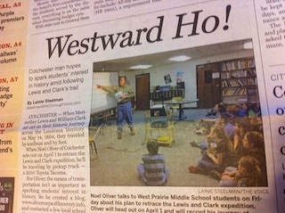
Westward Ho! McDonough Voice.com
When Meriwether Lewis and William Clark set out on their historic journey across the Louisiana Territory on May 14, 1804, they traveled by keelboat and by foot. When Noel Oliver of Colchester sets out on April 1 to retrace the Lewis and Clark expedition, he’ll be traveling by pickup truck — a 2010 Toyota Tacoma. For Oliver, the means of transportation isn’t as important as sparking students’ interest in history. So he created a blog, www.olivercorpsofdiscovery.info, and contacted a few local school districts, including West Prairie. During a talk to West Prairie fifth and sixth graders Friday, Oliver said he’s had a lifelong interest in the Lewis and Clark expedition. He grew up in East St. Louis and just across the Mississippi River from Camp River Dubois, where the duo started their journey. Click here for the rest of the...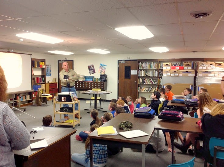
03-15-2013 West Prairie Middle School briefing
Almost 100 students from the 5th and 6th grade at West Prairie Middle School were briefed on my journey and they had a lot of questions. It was great to see their enthusiasm and curiosity. I also got a feel for what particular aspects of the journey are interesting to them. [alpine-phototile-for-picasa-and-google-plus src=”user_album” uid=”117292386093793315084″ ualb=”5855690096319995393″ imgl=”fancybox” dltext=”Picasa” style=”floor” row=”4″ num=”20″ size=”220″ border=”1″ highlight=”1″ align=”center”...
03-13-2013 International interest!
Just received word that elementary students from Prinsenbeek, Netherlands will be following my Lewis and Clark Journey. That’s exciting to know that students from another country are interested in out history and geography. Prinsenbeek is in the southern portion of the Netherlands, just North of the Belgium border. I am told that the students there will be interactive with me by email as the journey develops and we will even try to have a video conference with them at some time. Welcome to our Dutch students and thank you for following this...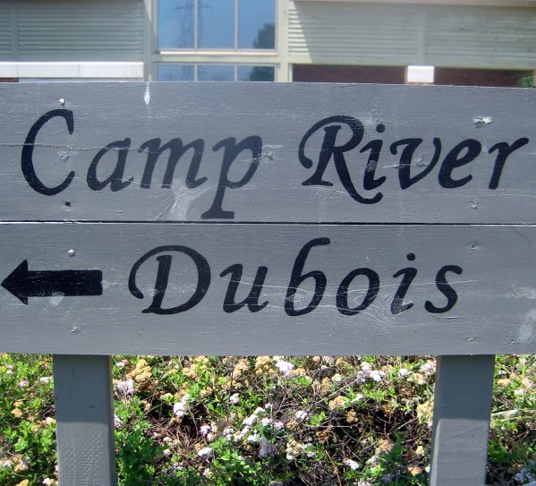
03-11-2013 First Right Answer on Homework Assignment
Justin G. of Quincy, IL was the first to submit a correct answer for the first homework assignment. The question was related to why Lewis & Clark camped on the Illinois side of the Mississippi River in preparation of their journey. Justin G. submitted the answer “The East side was US territory. The transaction for the Louisiana Territory was not yet complete and Lewis and Clark honored Spain’s request to stay out of the territory until the transfer was complete.” • Click here for a more complete answer from Wikipedia • Click here for the Oliver Corps of Discovery article on Camp River Dubois Here is a more complete answer from “Great River Road.com” • Cahokia Courthouse Cahokia, Illinois Cahokia was the first French settlement in the middle Mississippi Valley, being established in 1698 and for many years was the principal city in the region. Lewis arrived in Cahokia in December of 1803, and made contact with the influential residents of this town located across the river from St. Louis. Most notable of these were Nicholas Jarrot and John Hay who acted as interpreters when Lewis crossed the river to meet with the Spanish Governor Carlos Dehault Delassus. Clark arrived with the men and the boats on December 10 and waited for Lewis to return from St. Louis. When denied permission by Delassus to go up the Missouri River, the choice was made to set up winter quarters at the mouth of theWood River, directly across from the mouth of the Missouri River. Cahokia acted as post office and as a source of information and...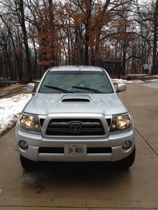
March 10, 2013 Getting the truck ready.
Preparing my “office space” inside the truck. Will include a desk in the front passenger seat. My laptop will work well on the desk and I can make the necessary notes at each stop of the day. My truck is a 2010 Toyota Tacoma, 4 wheel drive, 4 door, short bed. I will be using a TomTom GPS system for my navigation while in the truck and I also have a hand-held GPS to use when I am hiking and venturing outside of the truck. [alpine-phototile-for-picasa-and-google-plus src=”user_album” uid=”117292386093793315084″ ualb=”5853916323256752465″ imgl=”fancybox” dltext=”Picasa” style=”floor” row=”4″ num=”20″ size=”220″ border=”1″ highlight=”1″ align=”center”...
March 8, 2013 Radio Interview
WGEM 105 News/Talk Radio interview discussing the trip....
March 5, 2013 Only 27 days until departure.
Only 27 days remaining to prepare for the trip. I have a couple of important appointments that might be of interest to anyone already following the blog. Friday, March 8, I have an “on air interview” with a Quincy radio station at 7:50am. They want me to talk about the trip and the inclusion of elementary school students in the adventure. This interview will be with Greg Haubrich of WGEM News/Talk 105. Maybe a few more schools might hear about the trip in this interview and decide to join us. The more students, the better. Friday, March 15, I will be meeting with some fifth and sixth grade students at West Prairie Middle School. Their teacher, Mrs. Smith will also be assisting me in planning the daily blog information content and means of presentation. I am anxious to meet the students, tell them of my plans, and maybe create some enthusiasm on their part. It is even possible that one of them will be intrigued to the point that they will someday share an adventure with another...
February 24, 2013
Sunday afternoon, running of the Daytona 500, new snow on the ground here at home and I am getting nervous about preparations for my trip. My son Adam has been the brains behind setting up the web page for my blog. Adam is the founder and owner of 4D5W Inc., an internet marketing company, so this part of the preparation is in his forte. Having such professional assistance has been, is, and will be a real asset in the blogging of this adventure. The list of interested schools and individuals is growing steadily and I recently added a school in Shanghai, China to the list. My next step will be to make the web page public and to notify everyone of the URL so they can begin to follow the progress. Just 35 more days before I start. Still need to get my truck thoroughly checked out and serviced. Still need to configure plastic storage tubs to contain all my supplies and arrange them in the truck bed. A process very similar to that of Lewis and Clark as they began to pack their pirogue and boats. Just deciding “… the different articles necessary…” is a major task. In my case, if I have forgotten something important, I can make purchases as I travel; not so for the Corps of Discovery. Still need to publicize and get more interest/followers. Still need to plan major points of interest. Still need to re-read journals and make notes of significant quotes. Still need to study maps of all the states I am expecting to travel....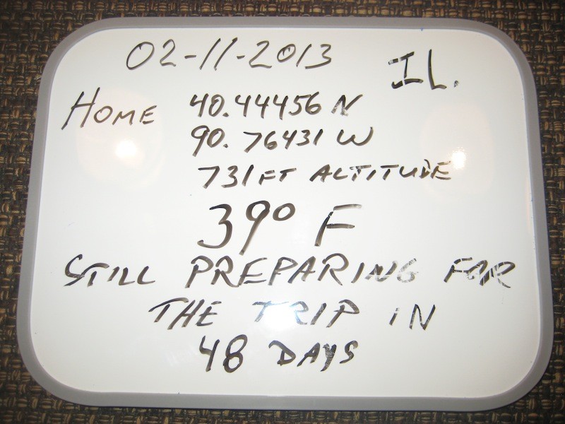
February 11th, 2013 – Whiteboard
Each day of the journey, I plan to start with a “whiteboard” to identify my current location and some geographic data. Students can use some of this data to develop their geography skills, math skills, map skills, and weather skills. On some days I may even use the metric system so students can practice converting from one to the other....