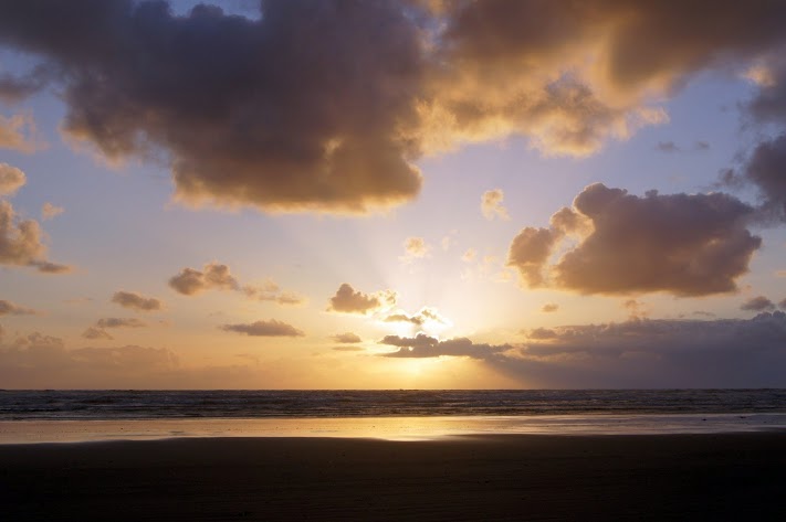
 For those of you still hanging around this website, here are some beach and sunset photos that I took today. [alpine-phototile-for-picasa-and-google-plus src=”user_album” uid=”117292386093793315084″ ualb=”5872480434157562689″ imgl=”fancybox” dltext=”Picasa” style=”floor” row=”4″ num=”160″ size=”220″ border=”1″ highlight=”1″ align=”center”...
 The Pacific was the destination assigned by President Jefferson and The Corps succeeded. So many months, and days, and miles, and troubles, and struggles and yet it is sad that it is over. That pretty well describes the feelings of Captains Lewis and Clark; and I must say it also describes my feelings. This afternoon, I am sad that it is over. I can honestly say that I have “planned” or at least dreamt about this journey since I was a young boy. Of course I didn’t know everything about their journey and I still don’t, even after this trip, but I knew enough about it that it created a deep curiosity and a yearning in me. I wanted to see at least some of the places they described and to contemplate their strengths and their drive. Now I have done just that. Numerous times, over the last 28 days, I have stood at the river bank, read a selection from their journals, looked upstream and pictured them rounding the bend headed west. I didn’t get to see any live grizzly bears and I didn’t get to the point that I had to eat anything undesirable, but I did see buffalos, an elk, a few bald eagles, a lot of ring-necked pheasants, and even a few prairie dogs. I didn’t have to “camp” in my truck even though I was prepared to do it if necessary. I did struggle a few days in the snow and several days in the rain, but I also had some beautiful sunshine that kept my spirits up. I ventured off the Lewis and Clark journey...
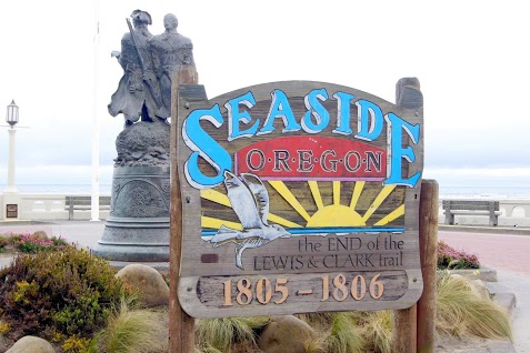 Cold, windy, and rainy; just as described in all their journals. The Oregon coast lived up to their descriptions in all aspects. A beautiful coast for sure, but cold and damp all day. As the one sign says, “The end of the Lewis and Clark Trail”. Seaside, OR N46.01491 W123.91120 Salt Works N45.98466 W123.93213 Ecola State Park N45.91955 W123.97405 Daily data: Beginning odometer at Comfort Inn, Astoria, OR was 31,025 miles. Ending odometer at the same place is 31,071 miles. Bought fuel at Astoria, OR. Bought 9.333 gallons @ $3.439 for a total of $32.10. [alpine-phototile-for-picasa-and-google-plus src=”user_album” uid=”117292386093793315084″ ualb=”5871666593272316209″ imgl=”fancybox” dltext=”Picasa” style=”floor” row=”4″ num=”150″ size=”220″ border=”1″ highlight=”1″ align=”center”...
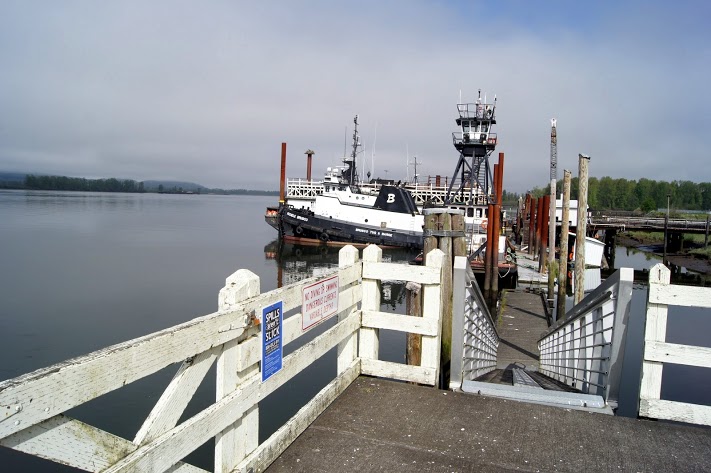 “Ocian in view ! O! the joy” Everyone was thrilled to learn that they actually made it to the Pacific Ocean as directed by President Jefferson. BUT, the last several days were not easy, in fact they were miserable but they made it. Daily data: Beginning odometer at the Days Inn in Greshem, Oregon was 30,806 miles. Ending odometer at the Comfort Inn in Astoria, Oregon is 30,997 miles. Fuel purchase at Cathlamet, Washington. Odometer was 30890, bought 12.443 gallons @ $3.739 for a total of $46.52.Meals for the day were $28.00 Meals for the day were $28.00 Lodging for the night is $105.60 [alpine-phototile-for-picasa-and-google-plus src=”user_album” uid=”117292386093793315084″ ualb=”5871345920197158977″ imgl=”fancybox” dltext=”Picasa” style=”floor” row=”4″ num=”150″ size=”220″ border=”1″ highlight=”1″ align=”center”...
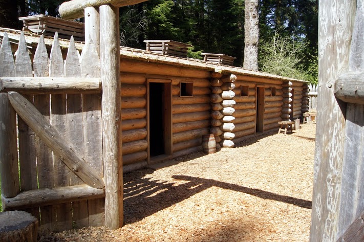 A fort, hastily built to survive the cold, wet winter of the Columbia River and the Pacific Ocean. Arriving in mid-November, the fort had to be built quickly to assist in their survival for the winter. The fort is much smaller than I expected, but it obviously fit their needs. N46.13397 W123.88036 [alpine-phototile-for-picasa-and-google-plus src=”user_album” uid=”117292386093793315084″ ualb=”5871344913245914625″ imgl=”fancybox” dltext=”Picasa” style=”floor” row=”4″ num=”150″ size=”220″ border=”1″ highlight=”1″ align=”center”...
 I didn’t cover many miles, but I did stay right on the river all day and saw some amazing sights. A few mountain streams and a departing view of Mt. Hood, which I think is one of my favorite places so far. Daily data: Beginning odometer at Best Western on Mt. Hood was 30,700 miles. Ending odometer at Days Inn in Gresham, Oregon is 30,805 miles. Bought fuel at Mt. Hood. Bought 9.687 galloons @ $4.129 for a total of 40.00. This was not a fill-up because of the price per gallon. I just wanted enough to be sure I could get down the mountain. Meals for the day was $29.00. Lodging for tonight is $65.57 + April 25, 2013 [alpine-phototile-for-picasa-and-google-plus src=”user_album” uid=”117292386093793315084″ ualb=”5870937786967077329″ imgl=”fancybox” dltext=”Picasa” style=”floor” row=”4″ num=”150″ size=”220″ border=”1″ highlight=”1″ align=”center”...
 Water level control, power production, transportation support and fish management; at the highest level. Very impressive operations. Although Lewis and Clark didn’t have to deal with them, the river is more navigable and the salmon are thriving. Cascade Locks N45.67088 W121.89283 Bonneville Dam N45.64223 W121.94269 [alpine-phototile-for-picasa-and-google-plus src=”user_album” uid=”117292386093793315084″ ualb=”5870939277808707121″ imgl=”fancybox” dltext=”Picasa” style=”floor” row=”4″ num=”150″ size=”220″ border=”1″ highlight=”1″ align=”center”...
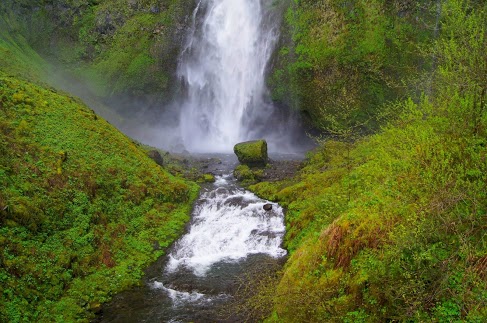 Surprisingly beautiful waterfalls Reminds me of some I saw in Hawaii. The walls of the gorge are steep and rocky with very thick greenery so it should not be a surprise that springs and snow melt would produce some pretty grand waterfalls. Horsetail Falls N45.59049 W122.06858 Multomah Falls N45.57842 W122.11894 [alpine-phototile-for-picasa-and-google-plus src=”user_album” uid=”117292386093793315084″ ualb=”5870941514422922305″ imgl=”fancybox” dltext=”Picasa” style=”floor” row=”4″ num=”150″ size=”220″ border=”1″ highlight=”1″ align=”center”...
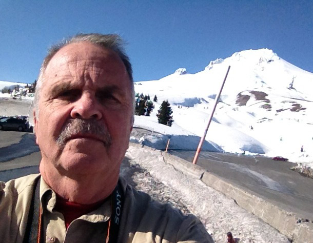 Mt. Hood had little to do with the Corps of Discovery journey, but they did see it and include it in their diaries as a major landmark. Its snow covered, pointed top is visible for more than 50 miles on the Columbia River. As you approach, mile by mile, it keeps getting bigger and taller. Now that I am here on the top, it is as majestic as I expected. N45.30312 W121.76526 Elevation 5,911 feet Daily data: Beginning odometer at Days Inn in Kennewick, WA was 30,488 miles Ending odometer at Best Western, Government Camp, Mt. Hood, Oregon is 30699 miles Meals were $24.00. Fuel purchased at Kennewick, WA, odometer 30448, bought 11.452 gallons @ $3.539 for a total of $40.53. Lodging for tonight is $88.16. [alpine-phototile-for-picasa-and-google-plus src=”user_album” uid=”117292386093793315084″ ualb=”5870593768737720321″ imgl=”fancybox” dltext=”Picasa” style=”floor” row=”4″ num=”150″ size=”220″ border=”1″ highlight=”1″ align=”center”...
 The Columbia River and the gorge it has created is the border between Oregon and Washington for the most part. Lewis and Clark were traveling pretty quickly on this part of their journey, but did run into difficulties with some of the rapids. Even though it was down stream, it was never easy or routine for them. [alpine-phototile-for-picasa-and-google-plus src=”user_album” uid=”117292386093793315084″ ualb=”5870586834439071281″ imgl=”fancybox” dltext=”Picasa” style=”floor” row=”4″ num=”150″ size=”220″ border=”1″ highlight=”1″ align=”center”...
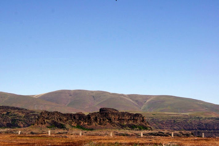
 Today’s travels show the variety of scenery on the Washington/Oregon State lines. A variety of terrains, vegetation and uses in just a relatively short distance. Some of the farm field photos make me think that their equipment must have seat belts and roll cages. They farm some pretty steep slopes and it makes some beautiful scenes. Daily data: Beginning odometer at Motel 6 in Clarkston, Washington was 30,210. Ending odometer at Days Inn in Kennewick, Washington is 30,448. One fuel stop at Clarkston. Odometer was 30,211. Bought 7,805 gallons @ $3.459 for a total of $27.00. Meals were $21.00 Lodging for tonight is $78.71. + April 23, 2013 [alpine-phototile-for-picasa-and-google-plus src=”user_album” uid=”117292386093793315084″ ualb=”5870213532276223009″ imgl=”fancybox” dltext=”Picasa” style=”floor” row=”4″ num=”150″ size=”220″ border=”1″ highlight=”1″ align=”center”...
 Of course this dam was not here when Lewis and Clark came through here, but it does give you an idea of how big the Columbia River really is. N45.93126 W119.29973 Elevation 269 feet [alpine-phototile-for-picasa-and-google-plus src=”user_album” uid=”117292386093793315084″ ualb=”5870211699186549761″ imgl=”fancybox” dltext=”Picasa” style=”floor” row=”4″ num=”150″ size=”220″ border=”1″ highlight=”1″ align=”center”...
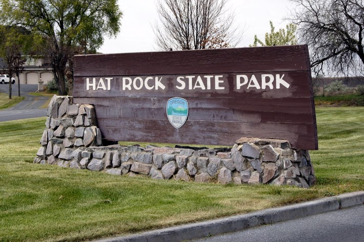 Why would the Corps of Discovery call this Hat Rock? More than one of their journals made note of this landmark. It was obvious to them from the river and they saw it on both their westbound journey and when they returned on their eastbound trip. N45.91765 W119.17062 Elevation 387 feet [alpine-phototile-for-picasa-and-google-plus src=”user_album” uid=”117292386093793315084″ ualb=”5870210419449301297″ imgl=”fancybox” dltext=”Picasa” style=”floor” row=”4″ num=”150″ size=”220″ border=”1″ highlight=”1″ align=”center”...
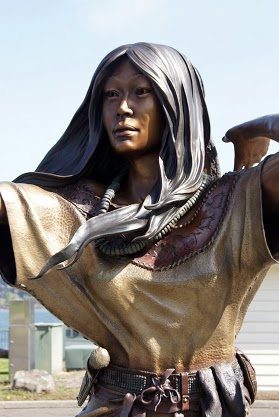
 Finally, they saw the Columbia River. The whole Corps was excited to finally get on the Columbia River because it was “all down hill from here”. Traveling downstream was so much faster than what they had been doing, it seemed almost effortless. The State of Washington chose this significant location to honor Sacagawea by establishing Sacagawea State Park and establishing a modest museum in her honor. N46.20032 W119.03932 Elevation 371 feet [alpine-phototile-for-picasa-and-google-plus src=”user_album” uid=”117292386093793315084″ ualb=”5870207325787929281″ imgl=”fancybox” dltext=”Picasa” style=”floor” row=”4″ num=”150″ size=”220″ border=”1″ highlight=”1″ align=”center”...
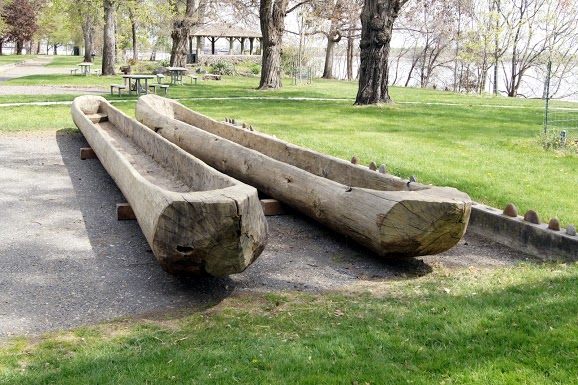
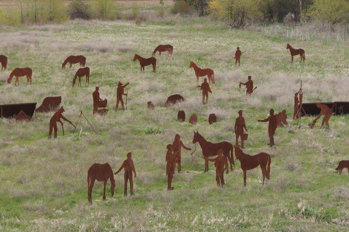 View both the campsite and all the players here. This campsite includes a pretty complete set of iron cutouts representing the people and activities of the campsite. Very interesting and well done. N46.34586 W117.93604 Elevation 1761 feet [alpine-phototile-for-picasa-and-google-plus src=”user_album” uid=”117292386093793315084″ ualb=”5870206100352623985″ imgl=”fancybox” dltext=”Picasa” style=”floor” row=”4″ num=”150″ size=”220″ border=”1″ highlight=”1″ align=”center”...
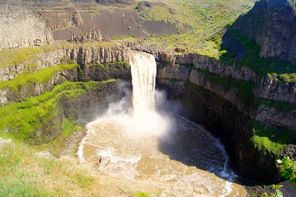 One of the most beautiful water falls in all of Washington. These falls are the only remaining major falls created by glacial floods 15,000 years ago. The Ranger related that the water is not always that muddy. The color is due to a heavy rain just the day before. N46.66368 W118.22744 Elevation 899 feet Daily data: Beginning odometer at Comfort Inn, Lewiston, Idaho was 30025. Ending odometer at Motel 6, Clarkston, Washington is 30,210. Fuel purchased at Clarkston, WA, odometer 30060, 12.860 gallons @ $3.459 for a total of $44.48. Meals for the day were $22.00 Lodging for the day is $47.07 [alpine-phototile-for-picasa-and-google-plus src=”user_album” uid=”117292386093793315084″ ualb=”5869850504698023649″ imgl=”fancybox” dltext=”Picasa” style=”floor” row=”4″ num=”150″ size=”220″ border=”1″ highlight=”1″ align=”center”...