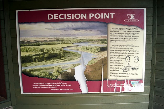
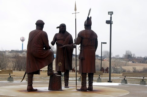
 Should we take the left river or the right river ? The Corps camped here several days and scouted each of hte streams to make sure they were going the right way. A mistake at this point probably would have resulted in failure or even worse–being totally stranded in the Bitterroot Mountains for the hardest part of the winter. They had been warned about the upcoming great falls, but not about the river choice. The Captains split up and scouted each one and then decided the South stream seemed most likely to be the one leading to the great falls. They chose correctly and the mission continued. [alpine-phototile-for-picasa-and-google-plus src=”user_album” uid=”117292386093793315084″ ualb=”5867948587449576977″ imgl=”fancybox” dltext=”Picasa” style=”floor” row=”4″ num=”150″ size=”220″ border=”1″ highlight=”1″ align=”center”...
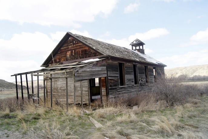 Spotted this off in the distance and just had to turn around and get a closer look. Looks like it may have been an old school or even a church. No signs of recent activity and no signs of critters living in it. Just an interesting site. Near Loma, Montana. N47.92003 W110.52641 Elevation 2591 feet [alpine-phototile-for-picasa-and-google-plus src=”user_album” uid=”117292386093793315084″ ualb=”5867956575430699345″ imgl=”fancybox” dltext=”Picasa” style=”floor” row=”4″ num=”150″ size=”220″ border=”1″ highlight=”1″ align=”center”...
 DETOUR—ROAD CLOSED–IMPASSABLE SNOW means do not go this way. My plan for the day was to drive to Fort Benton, Montana and visit some of the sites there and maybe end the day in Great Falls. Nature changed my plans again. I ended up driving straight to Great Falls and I will try to get to Fort Benton tomorrow. As it turned out, I was able to spend a couple hours at the Lewis and Clark National Historic Trail Interpretive Center in Great Falls. I am totally impressed with this facility and the staff that I met. It is the most complete, accurate, and well-kept center that I have seen so far. Their web site identifies them as the “Crown Jewel of the Lewis and Clark Trail” and I totally agree with that statement. Their web site is www.lewisandclarkfoundation.org. Be sure to look them up. You will learn a great deal about the Corps of Discovery through their displays. It is also a real asset in that you can look out the windows of the center and see the Missouri River and one of the falls. Today the view was a little obstructed by a blowing snow, but I am getting used to that. Their interpretive center takes the visitor from St. Charles, Missouri to Fort Clatsop and back to St. Charles. Extremely well done and aimed at elementary school children with a lot of hands-on displays. Their portrayal of the portage really demonstrates the struggles involved at that point of the journey. I am glad that my route was changed and that I had the extra time necessary to tour...
 My first impressions of Montana are beautiful and exciting. I have long imagined the Big Sky Country to be an impressive mix of mountains, grasslands, and rolling hills. In this first day of travel in Montana, I am seeing that I was on the right track with those expectations. The big sky has been full of snow and clouds so I have yet to see the expansive blue that is famous here. This is the 15th day of travel on this journey and the website has recorded well over 4600 views, which averages over 300 per day. To think that so many students are watching what I am doing is a bit intimidating. It drives me to do more and try harder to capture the adventure of Lewis and Clark and the Corps of Discovery. An early afternoon blizzard has caused me to bunker down a little early today, but I don’t expect to be stranded for days. I am spending the night in Lewistown, Montana. [alpine-phototile-for-picasa-and-google-plus src=”user_album” uid=”117292386093793315084″ ualb=”5867199262518646817″ imgl=”fancybox” dltext=”Picasa” style=”floor” row=”4″ num=”150″ size=”220″ border=”1″ highlight=”1″ align=”center”...
 Normally I would break this journal entry down into a few separate entries but….. I am just too tired to do that this time. It was a very long day and I am old you know. Started the day in Bismarck, North Dakota with a few photos of Sacagawea on the Capitol property. Next was a keelboat replica down by the Missouri River and a couple bridge photos. Then I went to Fort Mandan. This is where the expedition spent the first winter and where they met Sacagawea. Unexpectedly, the highlight of this stop was the statue of Seaman. A little larger than life-size, but very well done. Although the interpretive center was closed, I did get to wander through the replica of the fort. It seems strange to me that the interpretive center looked like it was open, there were a dozen cars in the parking lot, lights were on inside, but the doors were locked. There was no sign explaining that it was closed or why. Saturday morning within their posted open hours, but locked. My next stop was the North Dakota Lewis and Clark Interpretive Center in Washburn, North Dakota. Beautiful hilltop location just above the Missouri River. Elaborate well done displays, some interactive. The center is in the process of expanding with a new wing, but it doesn’t interfere with the existing displays. Very well done. Next in the photos you will see just a couple of oddities that I noticed during the day’s drive. My next stop was the Theodore Roosevelt National Park. This is one of the “best kept secrets” in our park system. I spent just over...
 Driving in the Dakotas today trying to make up the time lost by the Winter Storm Walda. The scenery in the Dakotas is amazing and varied. It is really an irony that when you see the snowy landscape it is so beautiful, but after driving 2 or 3 hours in it and it doesn’t change, it becomes boring. Actually stumbled across two monuments, one for Sitting Bull and one for Sakagawea. They are within 100 yards of each other on the banks of the Missouri River at one of its prettiest reservoirs, Lake Oahe near Mobridge, South Dakota. Neither of them have been very well maintained and they show signs of wear and abuse. I understand that the property is privately owned and not government supported, so that may be why they have deteriorated. These monuments are located at N45.51596 W100.48817, elevation 1800 ft. The question in my mind is, which state? North Dakota or South Dakota; I was thoroughly confused by the time I found them. More research for later. I have changed time zones back and forth between Central and Mountain time and I am not sure which zone I am in here in Bismarck, North Dakota. I guess it really doesn’t matter. Once in a while I will stop and take a picture of something (like the Bad River) and I really don’t know how it fits into the Lewis and Clark story other than a sign pointed me to it. I thought I had done a lot of research, but not enough for sure. I saw quite a few ring-necked pheasants today alongside the road but each time I tried to...
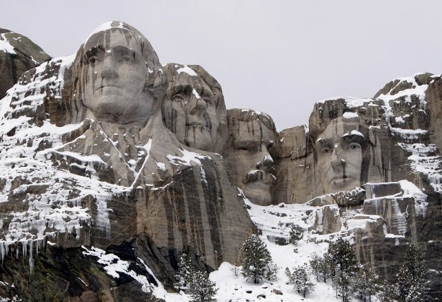 If these guys are not Lewis and Clark, who are they and what are they doing on my trip? I know that Mount Rushmore and the Badlands are not usually associated with Lewis and Clark, but they are so significant in both history and geography and I was very near, I just had to visit them. I want you to enjoy the photographs AND learn a bit about them. First of all, who are those guys carved on the mountain? Which face was completed first ? Which one last? Since I am not assigning this as a homework problem, I will just give you the answers, but I still want you to learn them. The men are George Washington, Thomas Jefferson, Abraham Lincoln, and Theodore Roosevelt. Washington’s face was completed in 1930, Jefferson in 1936, Lincoln in 1937, and Roosevelt in 1939. For more information, you can visit their website http://www.nps.gov/moru/index.htm [alpine-phototile-for-picasa-and-google-plus src=”user_album” uid=”117292386093793315084″ ualb=”5865730648718014561″ imgl=”fancybox” dltext=”Picasa” style=”floor” row=”4″ num=”80″ size=”220″ border=”1″ highlight=”1″ align=”center”...
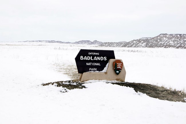 The Southwest corner of South Dakota has some amazing history and geography. In another journal entry, you will see the historic Mount Rushmore. In this journal entry, you will see examples of the unique geography of the area. The best tutorial I have found on the Badlands is one produced by the National Park Service http://www.nps.gov/badl/photosmultimedia/badlands-in-brief.htm Today when I was there the Ranger told me that they received over 3 feet of snow in the last couple days and that is the most he can remember in his 20 years there. The snow really made it beautiful and unusual. I was lucky to get up close with several big horn sheep, so enjoy those photographs. [alpine-phototile-for-picasa-and-google-plus src=”user_album” uid=”117292386093793315084″ ualb=”5865734925377383633″ imgl=”fancybox” dltext=”Picasa” style=”floor” row=”4″ num=”80″ size=”220″ border=”1″ highlight=”1″ align=”center”...
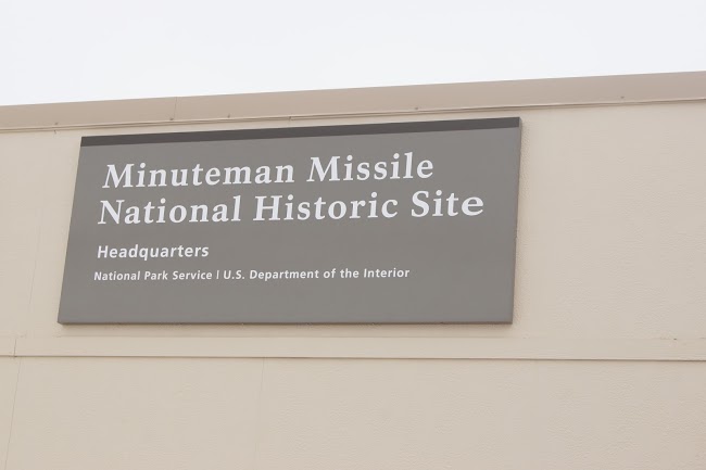 Just a 30 minute missile flight from here to Moscow. In 1961 this Minuteman Missile Site was designed and built to be a substantial threat to our Cold War Enemy Russia. These missiles were intercontinental ballistic missiles with a capability of striking Moscow in less than 30 minutes from their silo in South Dakota. These particular missiles had a 1.2 megaton warhead, equivalent to over a million tons of dynamite. None of these missile silos remain active since the end of the Cold War. You may have to ask someone older to help you better understand what the Cold War was. [alpine-phototile-for-picasa-and-google-plus src=”user_album” uid=”117292386093793315084″ ualb=”5865751953616197761″ imgl=”fancybox” dltext=”Picasa” style=”floor” row=”4″ num=”80″ size=”220″ border=”1″ highlight=”1″ align=”center”...
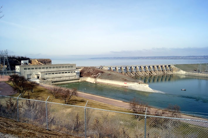 Gavins Point Dam is a hydroelectric dam on the Missouri River in the U.S. states of Nebraska and South Dakota. Built from 1952 to 1957, it impounds Lewis and Clark Lake. The dam is on the Nebraska-South Dakota border, west of Yankton, South Dakota. Gavins Point Dam is the lowermost dam on the Missouri, and was built as part of the Pick-Sloan Plan. The dam area (with Lewis and Clark Lake) is a very popular regional tourist destination. The next dam upstream is the Fort Randall Dam. The stretch of the Missouri immediately downstream of Gavins Point Dam is the only significant section of non-channelized meandering stream on the lower portion of the river. This federally designated Wild and Scenic River is among the last free-flowing stretches of the Missouri; it exhibits the islands, bars, chutes, and snags that once characterized the “Mighty Mo”. [alpine-phototile-for-picasa-and-google-plus src=”user_album” uid=”117292386093793315084″ ualb=”5864621877610599857″ imgl=”fancybox” dltext=”Picasa” style=”floor” row=”4″ num=”80″ size=”220″ border=”1″ highlight=”1″ align=”center” max=”100″] Content:...
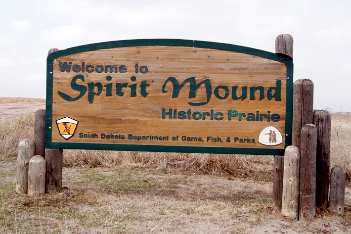 The Omaha, the Sioux, and the Otoes believe that the mound was occupied by spirits that killed any human who came near. Today when I visited the mound, there was a storm brewing nearby. As I walked toward the mound, the wind blew in my face almost as if it were pushing me away. I took a couple photos anyway. The sky continued to darken and a brilliant bolt of lightening cracked in the West. Enough for me. Spirit Mound? I hurried back to my truck with a few distant photos. That will have to do for today. On August 24, 1804, the day before they reached the mouth of the Vermillion, which they called the White Stone River, Clark wrote: “Capt Lewis and my Self Concluded to visit a High Hill Situated in an emence Plain three Leagues N. 20º W. from the mouth of White Stone river, this hill appear to be of a Conic form and by all the different Nations in this quater is Supposed to be a place of Deavels or that they are in human form with remarkable large heads and about 18 inches high; that they are very watchfull and ar armed with Sharp arrows with which they can kill at a great distance; they are said to kill all persons who are so hardy as to attemp to approach the hill; they state that tradition informs them than many indians have suffered by these little people and among others that three Maha men fell a sacrefice to their murcyless fury not meany years since- so much do the Mahas Souix Ottoes and other neibhbouring nations...
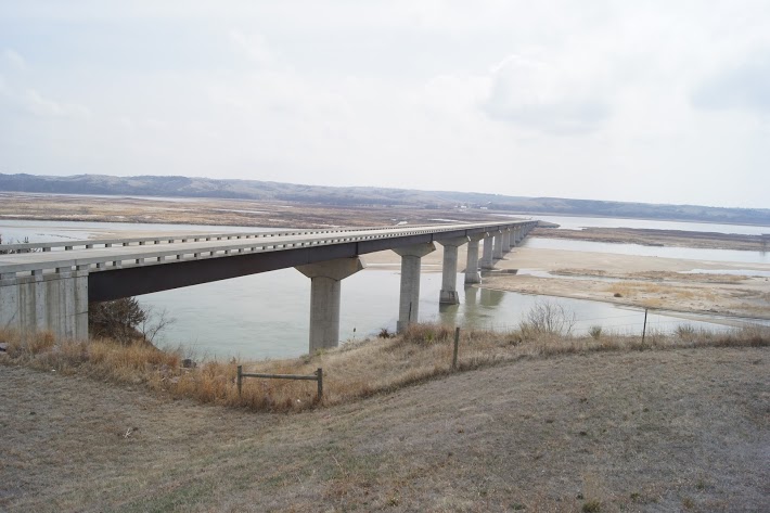 A beautiful, modern bridge over a particularly wide Missouri River valley. Chief Standing Bear was a Ponca Native American chief who successfully argued in U.S. District Court in 1879 in Omaha that Native Americans are “persons within the meaning of the law” and have the right of habeas corpus. His wife Susette Primeau was also a signatory on the 1879 writ that initiated the famous court case. N42.84948 W97.47814 Elevation 1237 feet [alpine-phototile-for-picasa-and-google-plus src=”user_album” uid=”117292386093793315084″ ualb=”5864626652628133697″ imgl=”fancybox” dltext=”Picasa” style=”floor” row=”4″ num=”80″ size=”220″ border=”1″ highlight=”1″ align=”center” max=”100″] Content:...
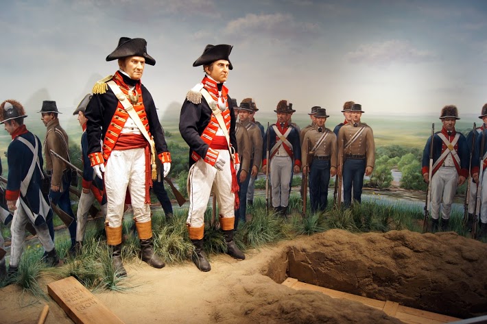 This is a private, non-profit cultural complex on the Missouri Riverfront. The beautiful center opened in 2002 in time to commemorate the Lewis and Clark Bicentennial in 2004. It expanded even further in 2007 to include an “Encounter Center”. The original wing is dedicated to Lewis and Clark and has some very unique displays that I thoroughly enjoyed. One is an animated Seaman barking at a prairie dog. The other is a very dramatic burial ceremony for Sgt. Floyd which includes Lewis and Clark paying tribute to their friend and fellow soldier. To think that this facility is privately funded and non-profit is almost unbelievable. Very well done and my thanks to the Missouri River Historical Development, Inc. Visit their website at siouxcitylcic.com [alpine-phototile-for-picasa-and-google-plus src=”user_album” uid=”117292386093793315084″ ualb=”5864255302497275185″ imgl=”fancybox” dltext=”Picasa” style=”floor” row=”4″ num=”80″ size=”220″ border=”1″ highlight=”1″ align=”center”...
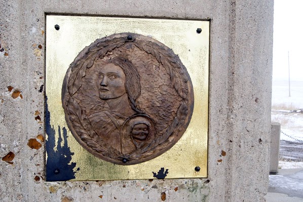
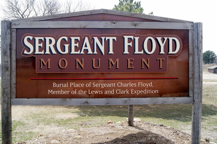 This memorial marks the grave of the only member of the Lewis and Clark Expedition to die during the historic journey. Sergeant Charles Floyd was a young man from Kentucky and he kept a journal on the expedition for ninety-nine days until he died on August 20, 1804, near the present day Sioux City, Iowa. On the afternoon of August 20, 1804, Corps of Discovery soldiers accorded their deceased comrade all the honors of war. All the soldiers were in full dress uniform for the burial high on a “handsome spot on the bluff” overlooking the Missouri River. The monument is a 100 foot sandstone obelisk and it was dedicated in 1901. In 1960 it became the first National Historic Landmark registered by the Natinoal park Service and U.S. Department of Interior. [alpine-phototile-for-picasa-and-google-plus src=”user_album” uid=”117292386093793315084″ ualb=”5864237548225712737″ imgl=”fancybox” dltext=”Picasa” style=”floor” row=”4″ num=”80″ size=”220″ border=”1″ highlight=”1″ align=”center”...
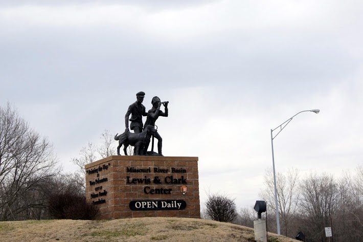 This is a beautiful, very well maintained, multifaceted facility that is a “must see” for Lewis and Clark buffs. Perfectly situated high above the Missouri River at Nebraska City, Nebraska, this facility has been able to combine many aspects of the Corps of Discovery. I think it is appropriate for the casual visitor that knows little or nothing about the great adventure, and it is appropriate for the well prepared student of Lewis and Clark. Each extreme will be able to absorb something of significance from this facility and its intriguing grounds. I had a short visit here on one evening just before they were closing for the day and an extended visit the next day. In both instances, the staff at the facility were more than cordial, very enthusiastic and knowledgable, and eager to ensure that my visit was a rewarding one. They were rightfully proud of their facility and they were determined to show it at its best. You might want to check out their web site too. CLICK HERE [alpine-phototile-for-picasa-and-google-plus src=”user_album” uid=”117292386093793315084″ ualb=”5863884262482926705″ imgl=”fancybox” dltext=”Picasa” style=”floor” row=”4″ num=”80″ size=”220″ border=”1″ highlight=”1″ align=”center”...
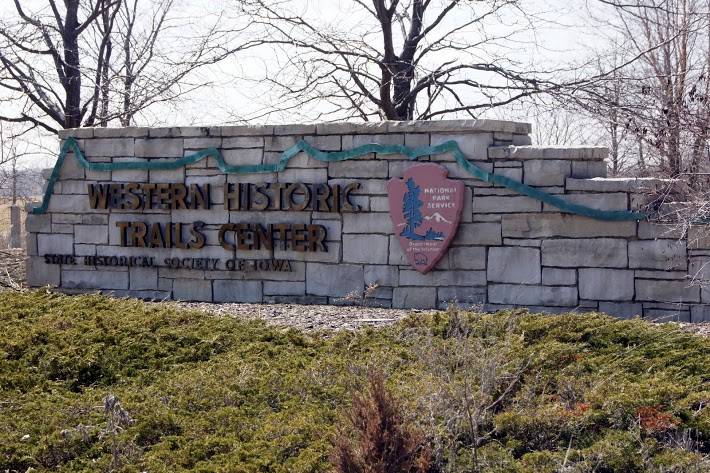 A visitors center aimed at drawing attention to all of the historic trails. Displays feature mock-up scenes from the Sante Fe Trail, the Oregon Trail, the Mormon Trail, the Lewis and Clark Trail, etc. To quote from one of the displays “The trails are about people… the pioneers who crossed the trails, the reasons for their crossings and the people who aided, or impeded their journeys.” N41.22788 W95.90059 Elevation 980 feet [alpine-phototile-for-picasa-and-google-plus src=”user_album” uid=”117292386093793315084″ ualb=”5863890906757454817″ imgl=”fancybox” dltext=”Picasa” style=”floor” row=”4″ num=”75″ size=”220″ border=”1″ highlight=”1″ align=”center”...