 Woke up to a dense fog this morning so I had a leisurely hotel-lobby-made waffle and several cups of pretty thick coffee. I am really starting to miss my own bed and my own….., well, I shouldn’t complain, this was my idea. The weather reports this morning are still warning of a major winter storm in the parts of the Dakotas that are in my immediate future. I was able to travel the whole day with little more than cloudy skies, quick blustery showers and one pretty impressive lightening strike at the Spirit Mound. This evening the weather reports are forecasting 18 inches to 24 inches with high winds and drifting for the next 24 to 48 hours. Lewis and Clark are getting even with me I think. All I can do is let the conditions dictate my travels. Had another correct answer today for the homework question on the photos with the spires. The person that answered today doesn’t get full credit because she failed to answer the second part of the question reference the source of the answer. Good job anyway. Start firing in some answers on today’s homework question. Have fun with it. See if your folks can help you with this one. I am hoping to venture off the Lewis and Clark trail for a bit and visit some other significant locations in South Dakota. I don’t want to give away all my secrets, so just wait and see what the weather allows. Daily data: Beginning odometer was 27, 196 miles at Vermillion, South Dakota. Ending odometer is 27,379 at Wagner, South Dakota. Bought fuel today...
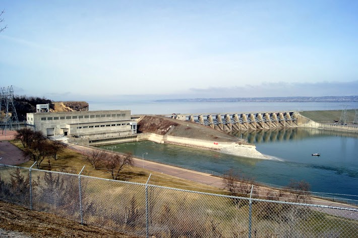 Gavins Point Dam is a hydroelectric dam on the Missouri River in the U.S. states of Nebraska and South Dakota. Built from 1952 to 1957, it impounds Lewis and Clark Lake. The dam is on the Nebraska-South Dakota border, west of Yankton, South Dakota. Gavins Point Dam is the lowermost dam on the Missouri, and was built as part of the Pick-Sloan Plan. The dam area (with Lewis and Clark Lake) is a very popular regional tourist destination. The next dam upstream is the Fort Randall Dam. The stretch of the Missouri immediately downstream of Gavins Point Dam is the only significant section of non-channelized meandering stream on the lower portion of the river. This federally designated Wild and Scenic River is among the last free-flowing stretches of the Missouri; it exhibits the islands, bars, chutes, and snags that once characterized the “Mighty Mo”. [alpine-phototile-for-picasa-and-google-plus src=”user_album” uid=”117292386093793315084″ ualb=”5864621877610599857″ imgl=”fancybox” dltext=”Picasa” style=”floor” row=”4″ num=”80″ size=”220″ border=”1″ highlight=”1″ align=”center” max=”100″] Content:...
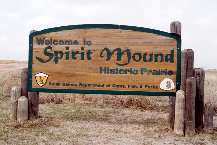 The Omaha, the Sioux, and the Otoes believe that the mound was occupied by spirits that killed any human who came near. Today when I visited the mound, there was a storm brewing nearby. As I walked toward the mound, the wind blew in my face almost as if it were pushing me away. I took a couple photos anyway. The sky continued to darken and a brilliant bolt of lightening cracked in the West. Enough for me. Spirit Mound? I hurried back to my truck with a few distant photos. That will have to do for today. On August 24, 1804, the day before they reached the mouth of the Vermillion, which they called the White Stone River, Clark wrote: “Capt Lewis and my Self Concluded to visit a High Hill Situated in an emence Plain three Leagues N. 20º W. from the mouth of White Stone river, this hill appear to be of a Conic form and by all the different Nations in this quater is Supposed to be a place of Deavels or that they are in human form with remarkable large heads and about 18 inches high; that they are very watchfull and ar armed with Sharp arrows with which they can kill at a great distance; they are said to kill all persons who are so hardy as to attemp to approach the hill; they state that tradition informs them than many indians have suffered by these little people and among others that three Maha men fell a sacrefice to their murcyless fury not meany years since- so much do the Mahas Souix Ottoes and other neibhbouring nations...
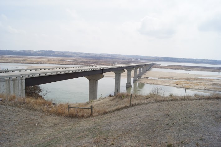 A beautiful, modern bridge over a particularly wide Missouri River valley. Chief Standing Bear was a Ponca Native American chief who successfully argued in U.S. District Court in 1879 in Omaha that Native Americans are “persons within the meaning of the law” and have the right of habeas corpus. His wife Susette Primeau was also a signatory on the 1879 writ that initiated the famous court case. N42.84948 W97.47814 Elevation 1237 feet [alpine-phototile-for-picasa-and-google-plus src=”user_album” uid=”117292386093793315084″ ualb=”5864626652628133697″ imgl=”fancybox” dltext=”Picasa” style=”floor” row=”4″ num=”80″ size=”220″ border=”1″ highlight=”1″ align=”center” max=”100″] Content:...
 See if you can determine the location of these photos. I realize most of the students will not know who Tom Brokaw is, so they may have to ask for some help from someone “older”. That’s OK to ask for help when you need it. CLICK HERE to contact me with your answers. [alpine-phototile-for-picasa-and-google-plus src=”user_album” uid=”117292386093793315084″ ualb=”5864633425353605521″ imgl=”fancybox” dltext=”Picasa” style=”floor” row=”4″ num=”80″ size=”220″ border=”1″ highlight=”1″ align=”center”...